Parsivel 2 sampling via linux
TL;DR;Summary
Sample the OTT Parsivel2 on a Linux device via Python and output data as ASDO-CSV and/or netCDF4 by using this code:
#!/bin/python3
import os
import time
import datetime
import serial
import subprocess
import numpy as np
import netCDF4 as nc
class parsivel_via_serial(serial.Serial):
def __init__(self,
# serial port parameters
# moxa is created as virtual USB0
# to setup most likely the RS-485 2W has to be activated
# by running
# setserial /dev/ttyUSB0 port 1
# for this to work, and also this program, the user than runs
# this file the user needs to be in the dialout group (for fedora),
# which can be done via the command:
# sudo usermod -a -G dialout $USER
# BE AWARE, a logout/reboot may be required
port='/dev/ttyUSB0',
baudrate = 57600,
ncmeta={'Station_Name': 'Eriswil (Kt. Bern, Switzerland)',
'latitude': 47.07051,
'longitude': 7.87254,
'altitude': 921,
'Sensor_ID': 411994,
'Title': 'CLOUDLAB (cloudlab.ethz.ch) disdrometer data from OTT Parsivel-2',
'Institution': 'ETH Zurich',
'Contact': "Jan Henneberger, janhe@ethz.ch;\n \
Robert Spirig, rspirig@ethz.ch;\n \
Fabiola Ramelli, ramellif@ethz.ch",
"Author": 'Robert Spirig, rspirig@ethz.ch',
},
outpath='./',
stationname='Eriswil',
quiet=True,
):
#
cmd = ['setserial','/dev/ttyUSB0', 'port', '1']
res = subprocess.call(cmd)
print(f'{cmd} call resulted in {res}')
if res != 0:
print('Setserial of the port to RS485-2W failed, ensure serialadapter is installed')
return
# inherit init from serial and open the port
super().__init__(port=port, baudrate=baudrate)
self.quiet = quiet
# a bytebuffer to hold the answer from the parsivel
self.buffer = b''
# how to decode the bytes to a sensible string, generally UTF8 is prefered
self.codec = 'utf-8'
# what to ask the parsivel, PA is the easiest, even if it is more than required
self.pollcmd = b'CS/PA\r'
# usual pollcmd for user telegram would be CS/P\r
#pollcmd = b"CS/P\r"
# for automatic polling, the time resolution in seconds
self.samplinginterval = 10
# when to stop sampling, can be synced with crontab
# and defaults to 15 minutes
self.maxsampling = 60 * 15
# where to store the data
self.outpath = outpath
# the prefix for the file to be used
self.fileprefix = 'parsivel_'
self.stationname = stationname[:10]
# holder for current file, will be filled by subroutines
self.ncfile = ''
self.csvfile = ''
# holder for all written files, will be filled by subroutines
self.csvfiles = []
self.ncfiles = []
# dict to hold data order by variable
self.data = {'-1': []}
# to keep track of whether we expect data in the buffer
self.polled = False
# for waiting a tenth of a second for new bytes in the buffer
self.waitdt = 0.1
# to keep track of the waiting time
self.waittime = 0
# the upper limit of waiting
self.maxwait = 3
# increment buffersize to hold more than one record, maybe useless
self.ReadBufferSize = 2**16;
# default output order, ASDO compatible
self.csvoutputorder = ['21','20', '01', '02', '03', '05', '06', '07',
'08', '10', '11', '12', '16', '17', '18', '34', '35', '93']
# default output header, ASDO compatible
self.csvheader = ['Date', 'Time', 'Intensity of precipitation (mm/h)', 'Precipitation since start (mm)', 'Weather code SYNOP WaWa',]
self.csvheader += ['Weather code METAR/SPECI', 'Weather code NWS', 'Radar reflectivity (dBz)', 'MOR Visibility (m)', ]
self.csvheader += ['Signal amplitude of Laserband', 'Number of detected particles', 'Temperature in sensor (°C)', ]
self.csvheader += ['Heating current (A)', 'Sensor voltage (V)', 'Optics status', 'Kinetic Energy', 'Snow intensity (mm/h)', 'Spectrum']
# add meta info forr ncfile
self.ncmeta = {
'Source': 'OTT Parsivel-2 optical disdrometer',
'History': 'Data acquired with MOXA USB converter',
'Dependencies': 'external',
'Conventions': 'CF-1.6 where applicable',
'Comment': "Manual of the OTT Parsivel-2 can be found online" \
" at https://www.ott.com",
"Licence": "For non-commercial use only. Any usage of the data"\
" should be reported to the contact person(s).",
}
self.ncmapping = {'09': 'interval',
'25': 'error_code',
'16': 'I_heating',
'17': 'V_sensor',
'18': 'state_sensor',
'10': 'sig_laser',
'01': 'rainfall_rate',
#'02': 'RR_total',
'03': 'synop_WaWa',
'04': 'synop_WW',
'07': 'radar_reflectivity',
'08': 'visibility',
'12': 'T_sensor',
'11': 'n_particles',
#'24': 'RR_accum',
'34': 'E_kin',
'90': 'number_concentration',
'91': 'fall_velocity',
'93': 'data_raw',
}
self.nctransformation = {'01': lambda x: x * 60 * 60 / 1000,
'12': lambda x: x + 273.15,
}
# add any other information from ncmeta
for key, value in ncmeta.items():
#if key.lower() in ['name', 'location']:
# key = f'Station_{key}'
self.ncmeta[key] = value
if not self.isOpen:
self.open()
self.flush()
def __del__(self):
self.close()
time.sleep(1)
def settime(self):
if not self.isOpen:
self.open()
time.sleep(1)
time.sleep(0.2)
now = datetime.datetime.now(datetime.UTC)
cmd = b'CS/T/'+bytes(now.strftime('%H:%M:%S\r').encode(self.codec))
if not self.quiet:
print('Sending settime command ', cmd)
update = self.write(cmd)
self.flush()
time.sleep(2)
answer = b''
if self.in_waiting > 0:
answer = self.read(size=self.in_waiting)
print('Answer to settime from parsivel was ', answer)
self.flush()
return answer.strip(b'\r\nOK\r\n\n').decode(self.codec).strip()
def gettime(self):
if not self.isOpen:
self.open()
time.sleep(1)
time.sleep(0.2)
cmd = b'CS/T\r'
if not self.quiet:
print('Sending gettime command ', cmd)
update = self.write(cmd)
self.flush()
time.sleep(2)
answer = b''
if self.in_waiting > 0:
answer = self.read(size=self.in_waiting)
print('Answer to gettime from parsivel was ', answer)
self.flush()
return answer.strip(b'\r\nOK\r\n\n').decode(self.codec).strip()
def setdate(self):
if not self.isOpen:
self.open()
time.sleep(1)
time.sleep(0.2)
now = datetime.datetime.now(datetime.UTC)
cmd = b'CS/D/'+bytes(now.strftime('%d.%m.%Y\r').encode(self.codec))
if not self.quiet:
print('Sending setdate command to parsivel ', cmd)
update = self.write(cmd)
self.flush()
time.sleep(2)
answer = b''
if self.in_waiting > 0:
answer = self.read(size=self.in_waiting)
print('Answer to setdate from parsivel was ', answer)
self.flush()
return answer.strip(b'\r\nOK\r\n\n').decode(self.codec).strip()
def getdate(self):
if not self.isOpen:
self.open()
time.sleep(1)
time.sleep(0.2)
cmd = b'CS/D\r'
if not self.quiet:
print('Requesting date via ', cmd)
update = self.write(cmd)
self.flush()
time.sleep(2)
answer = b''
if self.in_waiting > 0:
answer = self.read(size=self.in_waiting)
print('Answer to getdate from parsivel was ', answer)
self.flush()
return answer.strip(b'\r\nOK\r\n\n').decode(self.codec).strip()
def setrtc(self):
if not self.isOpen:
self.open()
time.sleep(1)
time.sleep(0.2)
now = datetime.datetime.now(datetime.UTC)
cmd = b'CS/U/'+bytes(now.strftime('%d.%m.%Y %H:%M:%S\r').encode(self.codec))
if not self.quiet:
print('Sending setrtc command', cmd)
update = self.write(cmd)
self.flush()
time.sleep(2)
answer = b''
if self.in_waiting > 0:
answer = self.read(size=self.in_waiting)
print('Answer to setrtc from parsivel was ', answer)
self.flush()
return answer.strip(b'\r\nOK\r\n\n').decode(self.codec).strip()
def getrtc(self):
if not self.isOpen:
self.open()
time.sleep(1)
time.sleep(0.2)
cmd = b'CS/U\r'
if not self.quiet:
print('Sending getrtc command to parsivel ', cmd)
update = self.write(cmd)
self.flush()
time.sleep(2)
answer = b''
if self.in_waiting > 0:
answer = self.read(size=self.in_waiting)
print('Answer to getrtc from parsivel was ', answer)
self.flush()
return answer.strip(b'\r\nOK\r\n\n').decode(self.codec).strip()
def setstationname(self):
if not self.isOpen:
self.open()
time.sleep(1)
time.sleep(0.2)
# max of 10 letter allowed
sname = self.stationname[:10]
cmd = b'CS/K/'+bytes(sname.encode(self.codec))
if not self.quiet:
print('Sending setstationname command to parsivel', cmd)
update = self.write(cmd)
self.flush()
time.sleep(2)
answer = b''
if self.in_waiting > 0:
answer = self.read(size=self.in_waiting)
print('Answer to setstationname ({sname}) from parsivel was', answer)
self.flush()
return answer.strip(b'\r\nOK\r\n\n').decode(self.codec).strip()
def getstationname(self):
if not self.isOpen:
self.open()
time.sleep(1)
time.sleep(0.2)
# max of 10 letter allowed
sname = self.stationname[:10]
cmd = b'CS/K\r'
if not self.quiet:
print('Sending getstationname command to parsivel', cmd)
update = self.write(cmd)
self.flush()
time.sleep(2)
answer = b''
if self.in_waiting > 0:
answer = self.read(size=self.in_waiting)
print('Answer to getstationname from parsivel was ', answer)
self.flush()
return answer.strip(b'\r\nOK\r\n\n').decode(self.codec).strip()
def setdatetime(self):
if not self.isOpen:
self.open()
time.sleep(1)
self.setrtc()
self.setdate()
self.settime()
def setup(self):
if not self.isOpen:
self.open()
time.sleep(1)
#sname = self.getstationname()
self.setstationname()
self.setdatetime()
self.flush()
def pollcode(self, code):
if not self.isOpen:
self.open()
time.sleep(1)
self.flush()
self.clearbuffer()
thispollcmd = str(code)
if int(thispollcmd) >= 90:
delim = ';'
sleeptime = 1
else:
delim = ''
sleeptime = 1
thispollcmd = (thispollcmd+delim).encode(self.codec)
pollcmd = b'CS/R/' + bytes(thispollcmd)+b'\r\n'
written = self.write(pollcmd)
#self.flush()
# according to manual there is a guarantee that the parsivel answers within 500 ms
# so we wait here to ensure the buffer is full
time.sleep(sleeptime)
self.polled = True
while self.in_waiting == 0 or self.waittime <= sleeptime:
time.sleep(self.waitdt)
self.waittime += self.waitdt
if self.waittime > self.maxwait:
if not self.quiet:
print(f'Breaking out of waiting for answer on serial as no data arrived after {self.maxwait} seconts!!!')
break
answer = ''
if self.in_waiting > 0:
answer = self.read_until() #size=self.in_waiting)
answer = answer.decode(self.codec)
self.flush()
self.polled = False
return answer
def help(self):
if not self.isOpen:
self.open()
time.sleep(1)
self.flush()
self.clearbuffer()
pollcmd = b'CS/?\r\n'
written = self.write(pollcmd)
self.flush()
# according to manual there is a guarantee that the parsivel answers within 500 ms
# so we wait here to ensure the buffer is full
time.sleep(1)
while self.in_waiting == 0 or self.waittime <= 0.5:
time.sleep(self.waitdt)
self.waittime += self.waitdt
if self.waittime > self.maxwait:
if not self.quiet:
print(f'Breaking out of waiting for answer on serial as no data arrived after {self.maxwait} seconts!!!')
break
answer = ''
if self.in_waiting > 0:
answer = self.read(size=self.in_waiting)
answer = answer.decode(self.codec)
print(answer)
def getconfig(self):
if not self.isOpen:
self.open()
time.sleep(1)
self.clearbuffer()
pollcmd = b'CS/L\r'
written = self.write(pollcmd)
# according to manual there is a guarantee that the parsivel answers within 500 ms
# so we wait here to ensure the buffer is full
time.sleep(0.5)
while self.in_waiting == 0 or self.waittime <= 0.5:
time.sleep(self.waitdt)
self.waittime += self.waitdt
if self.waittime > self.maxwait:
if not self.quiet:
print(f'Breaking out of waiting for answer on serial as no data arrived after {self.maxwait} seconts!!!')
break
answer = ''
if self.in_waiting > 0:
answer = self.read(size=self.in_waiting)
answer = answer.decode(self.codec)
#answer = answer.split('\r\n')
print(answer)
return answer
def poll(self):
if not self.isOpen:
self.open()
time.sleep(1)
self.flush()
self.clearbuffer()
written = self.write(self.pollcmd)
# according to manual there is a guarantee that the parsivel answers within 500 ms
# so we wait here to ensure the buffer is full
time.sleep(0.5)
self.polled = True
def clearbuffer(self):
# reset buffer in any case
self.buffer = b''
def cleardata(self):
# cleanup data dict after we've written out everything usually
self.data = {'-1': []}
def clear(self):
self.clearbuffer()
self.cleardata()
def velocity_classes(self):
"""
Return arrays of relevant velocity classes for use with TROPOS nc.
Hardcoded velocity bins of parsivel are used to construct:
1. velocitybin The sizes as lower -> upper edge
2. velocities as the the average velocity of a bin
3. the raw_velocities that have been used to construct the above 2
Returns
-------
velocitybin : array of float
The droplet sizes .
velocities : array of float
The bin widths as difference to lower and upper edge for each bin.
raw_velocities : array of float
The bin widths (raw as per manual).
"""
raw_velocities = [0.0] + \
[0.1] * 10 + \
[0.2] * 5 + \
[0.4] * 5 + \
[0.8] * 5 + \
[1.6] * 5 + \
[3.2] * 2
velocities = np.asarray([(raw_velocities[i] + raw_velocities[i + 1])/2
for i in range(len(raw_velocities[:-1]))])
velocitybin = np.cumsum(velocities)
return velocitybin, velocities, np.asarray(raw_velocities)
def diameter_classes(self, asmeters=True):
"""
Return arrays of relevant diameter classes for use with TROPOS nc.
Hardcoded bin widths of parsivel are used to construct:
1. dropletsizes The sizes as lower -> upper edge
2. dropletwidth as the the average of upper/lower edge
3. the sizes that have been used to construct the above 2
Returns
-------
dropletsizes : array of float
The droplet sizes .
dropletwidths : array of float
The bin widths as difference to lower and upper edge for each bin.
raw_dropletwidths : array of float
The bin widths (raw as per manual).
"""
raw_dropletwidths = [0.0] + \
[0.125] * 10 + \
[0.250] * 5 + \
[0.500] * 5 + \
[1] * 5 + \
[2] * 5 + \
[3] * 2
dropletwidths = [(raw_dropletwidths[i]+raw_dropletwidths[i+1])/2
for i in range(len(raw_dropletwidths[:-1]))]
dropletsizes = np.cumsum(dropletwidths)
if asmeters:
scaling = 1000
else:
scaling = 1
return dropletsizes / scaling, np.asarray(dropletwidths) / scaling, np.asarray(raw_dropletwidths) / scaling
# max sampling time in seconds (to be restarted by cronjob
def sample(self, writeoutfreq=None):
self.setup()
if writeoutfreq is None:
writeoutfreq = self.samplinginterval
if writeoutfreq % self.samplinginterval != 0:
print(f'Writoutfreq has been adjusted to be the lower multiple of the samplinginterval {self.samplinginterval}')
writeoutfreq = (writeoutfreq // self.samplinginterval) * self.samplinginterval
parsivel.reset_input_buffer()
time.sleep(1)
curdt = 0
try:
while curdt <= self.maxsampling or self.maxsampling <0:
parsivel.getparsiveldata()
#if curdt % 60 == 0:
if curdt % writeoutfreq == 0:
parsivel.write2file()
time.sleep(self.samplinginterval)
curdt += self.samplinginterval
except serial.SerialException:
print('Issue with serial connection encounted, rerun...')
except KeyboardInterrupt:
print('Sampling interrupted.')
def getparsiveldata(self):
if not self.isOpen:
self.open()
now = datetime.datetime.now(datetime.UTC)
self.flush()
time.sleep(0.1)
if not self.polled:
self.poll()
while self.in_waiting > 0 or self.waittime <= 0.6:
self.buffer += self.read(size=self.in_waiting)
curbytes = self.in_waiting
time.sleep(self.waitdt)
self.waittime += self.waitdt
if self.waittime > self.maxwait:
if not self.quiet:
print(f'Breaking out of waiting for answer on serial as no data arrived after {self.maxwait} seconds!!!')
break
# since we check after the time.sleep we can assume if there is nothing new that we are done
if curbytes == self.in_waiting and curbytes < 1:
if not self.quiet:
print(f'Breaking out of waiting for answer on serial as no new data has arrived after one more time step of {self.waitdr} after {self.waittime}!')
break
else:
if len(self.buffer) == 0:
if not self.quiet:
print(f'No bytes were available to read after {self.maxwait} seconds and we waited {self.waittime} seconds for an answer. ')
elif len(self.buffer) > 1:
if not self.quiet:
print(f'{len(self.buffer)} bytes have been read in {self.waittime} seconds. ')
else:
pass
if not self.quiet:
print('Received the following answer to poll:\n', self.buffer)
self.waittime = 0
self.polled = False
# convert to sensible string
record = self.buffer.strip(b'\x03').decode(self.codec).strip()
# get different fields into list
record = record.split('\r\n')
# split into measurement value key and measurement value
# the default return is CODE (2 Letters): data (until prev. removed \r\n
record = {i[:2]: i[3:].rstrip(';').strip() for i in record[1:]}
for key, value in sorted(record.items()):
# maintenance codes
if key in ['94', '95', '96', '97', '98', '99']:
continue
# build up the dict to hold the available data
if key not in self.data:
self.data[key] = []
# date, time, software versions that should not be converted
# as well as synop codes, sensor date/time and measuring start
# as we handle these ourselves
if key in ['20', '21', '14', '15', '05', '06', '19', '21', '22']:
pass
# spectra data
elif key in ['90', '91', '93']:
value = value.replace('000','')
if value.count(';') == len(value):
value = np.zeros((32, 32))
else:
# spectra numbers are int
if key in ['93']:
value = [int(i) if i else 0 for i in value.split(';')]
# others are float
elif key in ['90', '91']:
value = [float(i) if i else 0 for i in value.split(';')]
value = np.asarray(value)
if key in ['93']:
try:
value = value.reshape(32, 32)
except ValueError:
print(value.shape)
# fake data of the right format as apparently the serial comm was interruped
# this is usually the case if the script is running as several instance
_value = np.zeros((32,32))
value = _value.flatten()[:len(value)] + value
else:
# float
if '.' in value and value.count('.') == 1:
value = float(value)
else:
# maybe integer?
try:
value = int(value)
# neither float nor integer, maybe a weather code, like wawa
except ValueError:
print(f'Conversion to int failed for {value}, based on {key}')
pass
self.data[key] += [value]
# replace sensor time with system time
# 21 = date, 20 = time
if '20' in self.data and '21' in self.data:
self.data['21'][-1] = now.strftime('%d.%m.%Y')
self.data['20'][-1] = now.strftime('%H:%M:%S')
# keep unix time seperate
self.data['-1'] += [datetime.datetime.timestamp(now)]
else:
print(f'Issue with sampling as no date or time was passed in the serial buffer, skipping {now} and cleaning up buffer')
print(record, self.data)
for key, value in sorted(record.items()):
if (self.data[key]) >= 1:
self.data[key].pop()
# cleanup buffer in any case
self.clearbuffer()
def write2file(self, *args, **kwargs):
self.write2asdofile(*args, **kwargs)
self.write2ncfile(*args, **kwargs)
self.clear()
def _setupncfile(self):
if os.path.exists(self.ncfile):
nchandle = nc.Dataset(self.ncfile, 'a', format='NETCDF3_CLASSIC')
return nchandle
if not self.quiet:
print(f'Setting up {outfile}')
nchandle = nc.Dataset(self.ncfile, 'w', format='NETCDF3_CLASSIC')
nchandle.createDimension('time', None)
nchandle.createDimension('diameter', 32)
nchandle.createDimension('velocity', 32)
nchandle.createDimension('nv', 2)
for key, value in self.ncmeta.items():
setattr(nchandle, key, value)
now = datetime.datetime.now(datetime.UTC)
setattr(nchandle, "Processing_date", str(datetime.datetime.now(datetime.UTC)) + ' (UTC)')
datavar = nchandle.createVariable('lat', 'd', ())
setattr(datavar, 'standard_name', 'latitude')
setattr(datavar, 'long_name', 'Latitude of instrument location')
setattr(datavar, 'units', 'degrees_north')
datavar.assignValue(self.ncmeta['latitude'])
datavar = nchandle.createVariable('lon', 'd', ())
setattr(datavar, 'standard_name', 'longitude')
setattr(datavar, 'long_name', 'Longitude of instrument location')
setattr(datavar, 'units', 'degrees_east')
datavar.assignValue(self.ncmeta['longitude'])
datavar = nchandle.createVariable('zsl', 'd', ())
setattr(datavar, 'standard_name', 'altitude')
setattr(datavar, 'long_name',
'Altitude of instrument sensor above mean sea level')
setattr(datavar, 'units', 'm')
datavar.assignValue(self.ncmeta['altitude'])
datavar = nchandle.createVariable('time', 'i', ('time',))
setattr(datavar, 'standard_name', 'time')
setattr(datavar, 'long_name',
'Unix time at start of data transfer in seconds after 00:00 UTC on 1/1/1970')
setattr(datavar, 'units', 'seconds since 1970-01-01 00:00:00')
setattr(datavar, 'bounds', 'time_bnds')
setattr(datavar, 'comment',
'Time on data acquisition pc at initialization of serial connection to Parsivel.')
datavar = nchandle.createVariable('time_bnds', 'i', ('time', 'nv'))
setattr(datavar, 'standard_name', 'Measurement interval bounds') # time_bnds
setattr(datavar, 'long_name', 'Timespan of the measurement interval')
setattr(datavar, 'units', 's')
setattr(datavar, 'comment', 'Upper and lower bounds of measurement interval.')
datavar = nchandle.createVariable('interval', 'i', ('time',))
setattr(datavar, 'standard_name', 'Time interval') # interval
setattr(datavar, 'long_name', 'Length of measurement interval')
setattr(datavar, 'units', 's')
setattr(datavar, 'comment',
'Variable 09 - Sample interval between two data retrieval requests.')
diameters = self.diameter_classes()
datavar = nchandle.createVariable('diameter', 'd', ('diameter',))
setattr(datavar, 'standard_name', 'Particle diameter') # diameter
setattr(datavar, 'long_name', 'Center diameter of precipitation particles')
setattr(datavar, 'units', 'm')
setattr(datavar, 'comment',
'Predefined diameter classes. Note the variable bin size.')
datavar[:] = diameters[0]
datavar = nchandle.createVariable('diameter_spread', 'd', ('diameter',))
setattr(datavar, 'standard_name', 'Particle spread') # diameter spread
setattr(datavar, 'long_name', 'Width of diameter interval')
setattr(datavar, 'units', 'm')
setattr(datavar, 'comment', 'Bin size of each diameter class.')
datavar[:] = (diameters[1])
datavar = nchandle.createVariable('diameter_bnds', 'i', ('diameter', 'nv'))
setattr(datavar, 'standard_name', 'Particle bounds') # diameter bnds
setattr(datavar, 'long_name', 'Bounds of the diameter interval')
setattr(datavar, 'units', 'm')
setattr(datavar, 'comment', 'Upper and lower bounds of diameter interval.')
datavar[:, :] = np.stack([np.cumsum(diameters[2][:-1]), np.cumsum(diameters[2][1:])]).T
velocities = self.velocity_classes()
datavar = nchandle.createVariable('velocity', 'd', ('velocity',))
setattr(datavar, 'standard_name', 'Fall velocity') # veloc
setattr(datavar, 'long_name',
'Center fall velocity of precipitation particles')
setattr(datavar, 'units', 'm s-1')
setattr(datavar, 'comment',
'Predefined velocity classes. Note the variable bin size.')
datavar[:] = (velocities[0])
datavar = nchandle.createVariable('velocity_spread', 'd', ('velocity',))
setattr(datavar, 'standard_name', 'Fall velocity spread') # vel spred
setattr(datavar, 'long_name', 'Width of velocity interval')
setattr(datavar, 'units', 'm')
setattr(datavar, 'comment', 'Bin size of each velocity interval.')
datavar[:] = (velocities[1])
datavar = nchandle.createVariable('velocity_bnds', 'd', ('velocity', 'nv'))
setattr(datavar, 'standard_name', 'Fall velocity bounds') # vel bnds
setattr(datavar, 'comment', 'Upper and lower bounds of velocity interval.')
datavar[:, :] = np.stack([np.cumsum(velocities[2][:-1]), np.cumsum(velocities[2][1:])]).T
datavar = nchandle.createVariable(
'data_raw', 'd', ('time', 'diameter', 'velocity',), fill_value=-999.)
setattr(datavar, 'standard_name', 'Particle count per velocity and diameter bin') # data_raw
setattr(datavar, 'long_name',
'Raw Data as a function of particle diameter and velocity')
setattr(datavar, 'units', '1')
setattr(datavar, 'comment', 'Variable 93 - Raw data.')
datavar = nchandle.createVariable(
'number_concentration', 'd', ('time', 'diameter',), fill_value=-999.)
setattr(datavar, 'standard_name', 'Total particle count in time interval') # n_particles
setattr(datavar, 'long_name', 'Number of particles per diameter class')
setattr(datavar, 'units', 'log10(m-3 mm-1)')
setattr(datavar, 'comment', 'Variable 90 - Field N (d)')
datavar = nchandle.createVariable(
'fall_velocity', 'd', ('time', 'diameter',), fill_value=-999.)
setattr(datavar, 'standard_name', 'Fall velocity') # radar refl
setattr(datavar, 'long_name', 'Average velocity of each diameter class')
setattr(datavar, 'units', 'm s-1')
setattr(datavar, 'comment', 'Variable 91 - Field v (d)')
datavar = nchandle.createVariable('n_particles', 'i', ('time',))
setattr(datavar, 'standard_name', 'Total particle count in time interval') # n particles
setattr(datavar, 'long_name', 'Number of particles in time interval')
setattr(datavar, 'units', '#')
setattr(datavar, 'comment', 'Variable 11 - Number of detected particles')
datavar = nchandle.createVariable(
'rainfall_rate', 'd', ('time',), fill_value=-999.)
setattr(datavar, 'standard_name', 'rainfall_rate')
setattr(datavar, 'long_name', 'Precipitation rate')
setattr(datavar, 'units', 'm s-1')
setattr(datavar, 'comment', 'Variable 01 - Rain intensity (32 bit) 0000.000')
datavar = nchandle.createVariable(
'radar_reflectivity', 'd', ('time',), fill_value=-999)
setattr(datavar, 'standard_name', 'equivalent_reflectivity_factor')
setattr(datavar, 'long_name', 'equivalent radar reflectivity factor')
setattr(datavar, 'units', 'dBZ')
setattr(datavar, 'comment', 'Variable 07 - Radar reflectivity (32 bit).')
datavar = nchandle.createVariable('E_kin', 'd', ('time',), fill_value=-999.)
setattr(datavar, 'standard_name', 'Kinetic energ') # ekin
setattr(datavar, 'long_name', 'Kinetic energy of the hydrometeors')
setattr(datavar, 'units', 'kJ')
setattr(datavar, 'comment', 'Variable 24 - kinetic Energy of hydrometeors.')
datavar = nchandle.createVariable(
'visibility', 'i', ('time',), fill_value=-999)
setattr(datavar, 'standard_name', 'Visibility') # visi
setattr(datavar, 'long_name', 'Visibility range in precipitation after MOR')
setattr(datavar, 'units', 'm')
setattr(datavar, 'comment',
'Variable 08 - MOR visibility in the precipitation.')
datavar = nchandle.createVariable(
'synop_WaWa', 'i', ('time',), fill_value=-999)
setattr(datavar, 'standard_name', 'Synop Code WaWa') # synop wawa
setattr(datavar, 'long_name', 'Synop Code WaWa')
setattr(datavar, 'units', '1')
setattr(datavar, 'comment',
'Variable 03 - Weather code according to SYNOP wawa Table 4680.')
datavar = nchandle.createVariable(
'synop_WW', 'i', ('time',), fill_value=-999)
setattr(datavar, 'standard_name', 'Synop Code WW') # synop ww
setattr(datavar, 'long_name', 'Synop Code WW')
setattr(datavar, 'units', '1')
setattr(datavar, 'comment',
'Variable 04 - Weather code according to SYNOP ww Table 4677.')
datavar = nchandle.createVariable(
'T_sensor', 'i', ('time',), fill_value=-999)
setattr(datavar, 'standard_name', 'Temperature') # T_sensor
setattr(datavar, 'long_name', 'Temperature in the sensor')
setattr(datavar, 'units', 'K')
setattr(datavar, 'comment', 'Variable 12 - Temperature in the Sensor')
datavar = nchandle.createVariable('sig_laser', 'i', ('time',))
setattr(datavar, 'standard_name', 'Laser signal amplitude') # sig_laser
setattr(datavar, 'long_name', 'Signal amplitude of the laser')
setattr(datavar, 'units', '1')
setattr(datavar, 'comment',
'Variable 10 - Signal ambplitude of the laser strip')
datavar = nchandle.createVariable('state_sensor', 'i', ('time',))
setattr(datavar, 'standard_name', 'State of the Sensor') # v_sensor
setattr(datavar, 'long_name', 'State of the Sensor')
setattr(datavar, 'units', '1')
setattr(datavar, 'comment', 'Variable 18 - Sensor status:\n'\
'0: Everything is okay.\n' \
'1: Dirty but measurement possible.\n'\
'2: No measurement possile')
datavar = nchandle.createVariable('V_sensor', 'd', ('time',))
setattr(datavar, 'standard_name', 'Sensor Voltage') # v_sensor
setattr(datavar, 'long_name', 'Sensor Voltage')
setattr(datavar, 'units', 'V')
setattr(datavar, 'comment', 'Variable 17 - Power supply voltage in the sensor.')
datavar = nchandle.createVariable('I_heating', 'd', ('time',))
setattr(datavar, 'standard_name', 'Heating Current') # I_heating
setattr(datavar, 'long_name', 'Heating Current')
setattr(datavar, 'units', 'A')
setattr(datavar, 'comment', 'Variable 16 - Current through the heating system.')
datavar = nchandle.createVariable('error_code', 'i', ('time',))
setattr(datavar, 'standard_name', 'Error code') # Errors codes
setattr(datavar, 'long_name', 'Error Code')
setattr(datavar, 'units', '1')
setattr(datavar, 'comment', 'Variable 25 - Error code.')
return nchandle
def write2ncfile(self, intosubdirs=True, ):
if self.data and '21' in self.data:
pass
else:
if not self.quiet:
print('No data have been read yet. Call getparsiveldata() first.')
return
if not self.outpath.endswith(os.sep):
self.outpath += os.sep
os.makedirs(self.outpath, exist_ok=True)
if '21' in self.data:
pass
else:
print('No records to write yet in self.data')
return
if '21' in self.data and len(self.data['21']) > 0:
pass
else:
print('No records to write yet in self.data')
return
udays = sorted(list(set(self.data['21'])))
for day in udays:
if intosubdirs:
ymd = day.split('.')[::-1]
ymd = [i + j for i, j in zip(['Y', 'M', 'D'], ymd)]
_outpath = self.outpath+os.sep.join(ymd)+os.sep
os.makedirs(_outpath, exist_ok=True)
else:
_outpath = self.outpath
# day has the format d.m.Y but we want the filename to be Ymd
outfile = self.fileprefix +''.join(day.split('.')[::-1]) + '.nc'
self.ncfile = _outpath + outfile
nchandle = self._setupncfile()
setattr(nchandle, 'Date', day)
index_of_day = [i[0] for i in enumerate(self.data['21']) if i[1] == day]
curtimestep = nchandle.dimensions['time'].size
unixtime = ([self.data['-1'][i] for i in index_of_day])
nchandle.variables["time"][curtimestep] = (unixtime)
bnds = [[self.data['-1'][i] - int(self.data['09'][i]), self.data['-1'][i]] for i in index_of_day]
nchandle.variables['time_bnds'][curtimestep, :] = (bnds)
varNames = nchandle.variables.keys()
for ncvar in self.ncmapping:
thisvar = nchandle.variables[self.ncmapping[ncvar]]
thisdata = [self.data[ncvar][i] for i in index_of_day]
if ncvar in self.nctransformation:
thisdata = [self.nctransformation[ncvar](i) for i in thisdata]
if len(thisvar.shape) == 1:
thisvar[curtimestep] = (thisdata)
elif len(thisvar.shape) == 2:
thisvar[curtimestep, :] = (thisdata)
elif len(thisvar.shape) == 3:
thisdata = np.asarray(thisdata).reshape(thisvar.shape[1:])
thisvar[curtimestep, :, :] = (thisdata)
nchandle.close()
now = datetime.datetime.now(datetime.UTC)
print(f'Written {len(index_of_day)} records of data to {self.ncfile} at {now}')
self.ncfiles = list(set(self.ncfiles+[self.ncfile]))
pass
# order can be anything, but defaults to ASDO format, see header in below function
def write2asdofile(self, intosubdirs=True, varorder=[], header=[]):
assert len(varorder) == len(header), 'Order of variables and header have to match'
if self.data:
pass
else:
print('No data have been read yet. Call getparsiveldata() first.')
return
if varorder:
self.csvoutputorder = varorder
if header:
self.csvheader = header
if not self.outpath.endswith(os.sep):
self.outpath += os.sep
os.makedirs(self.outpath, exist_ok=True)
filemode = 'a'
# examples ASDO file
#04.03.2023,00:00:00,0.000,216.57,0,NP,C,-9.999,20000,19866,0,-1,0.64,23.8,0,0.000,0,<SPECTRUM>ZERO</SPECTRUM>
#2023.03.28,14:30:58,0.0,33.06,0,NP,C,-9.999,20000,21649,0,16,0.0,23.8,0,0.0,0.0,<SPECTRUM></SPECTRUM>
# 25.02.2023,00:05:30,3.100,210.07,62,RA,R,32.661,8290,16569,90,1,0.00,23.8,0,53.310,0,
# <SPECTRUM>,,,,,,,,,,,,,,,,,,,,,,,,,,,,,,,,,,,,,,,,,,,,,,,,,,,,,,,,,,,,,,,,,,,,,,,,,,,,,,,,,,,,,,,,,,,,,,,,,,
# ,,,,,,,,,,,,,,,,,,,,,,,,,,,,,,,,,,,,,,,,,,,,,,,,,,,,,,,,,,,,,,,,,,,,,,,,,,,,,,,,,,,,,,,,,,,,,,,,,,,,,,,,,,,,
# ,,,,,,,,,,,,,,,,,,,,2,,,,,,,,,,,,,,,,,,,,,,,,,,,,,,,,,,,,,,,,,,,,,,,,,,,,,,,,,,,,,,,,,,,,,,,,,,,,,,,,,,,,,,,
#,,,,,,,,,2,,,,,,,,,,,,,,,,,,,,,,,,,,,,,,,,1,1,,,,,,,,,,,,,,,,,,,,,,,,,,,,,,,1,,1,,,,,,,,,,,,,,,,,,,,,,,,,,,,,
#,1,,1,,,,,,,,,,,,,,,,,,,,,,,,,,,,,,,,1,,,,,,,,,,,,,,,,,,,,,,,,,,,,,,,,5,2,2,1,,,,,,,,,,,,,,,,,,,,,,,,,,,,,,1,
#4,,,,,,,,,,,,,,,,,,,,,,,,,,,,,,1,1,5,,,,,,,,,,,,,,,,,,,,,,,,,,,,,,,,2,1,1,,,,,,,,,,,,,,,,,,,,,,,,,,,,,1,1,,3,
#1,,,,,,,,,,,,,,,,,,,,,,,,,,,,,2,,4,10,7,,,,,,,,,,,,,,,,,,,,,,,,,,,,,,,3,8,3,,,,,,,,,,,,,,,,,,,,,,,,,,,,,,,,4,
#2,,,,,,,,,,,,,,,,,,,,,,,,,,,,,,,,,2,,,,,,,,,,,,,,,,,,,,,,,,,,,,,,,1,,,,,,,,,,,,,,,,,,,,,,,,,,,,,,,,,,1,,,,,,,,,,,,
#,,,,,,,,,,,,,,,,,,,,,,,,,,,,,,,,,,,,,,,,,,,,,,,,,,,,,,,,,,,,,,,,,,,,,,,,,,,,,,,,,,,,,,,,,,,,,,,,,,,,,,,,,,,,,,,,,,
#,,,,,,,,,,,,,,,,,,,,,,,,,,,,,,,,,,,,,,,,,,,,,,,,,,,,,,,,,,,,,,,,,,,,,,,,,,,,,,,,,,,</SPECTRUM>
if '21' in self.data:
pass
else:
print('No records to write yet in self.data')
return
if '21' in self.data and len(self.data['21']) > 0:
pass
else:
print('No records to write yet in self.data')
return
udays = sorted(list(set(self.data['21'])))
for day in udays:
if intosubdirs:
ymd = day.split('.')[::-1]
ymd = [i + j for i, j in zip(['Y', 'M', 'D'], ymd)]
_outpath = self.outpath+os.sep.join(ymd)+os.sep
os.makedirs(_outpath, exist_ok=True)
else:
_outpath = self.outpath
# day has the format d.m.Y but we want the filename to be Ymd
self.csvfile = self.fileprefix +''.join(day.split('.')[::-1]) + '.csv'
writeheader = True
# write out the buffer to file
if os.path.exists(_outpath + self.csvfile):
writeheader = False
# maxtimesteps because self.data holds everything
ntimesteps = len(self.data['20'])
with open(_outpath+self.csvfile, filemode) as fo:
if writeheader:
fo.write(','.join(self.csvheader))
fo.write('\n')
for timestep in range(ntimesteps):
# skip if not the same day
if self.data['21'][timestep] != day:
continue
for key in self.csvoutputorder:
varrec = self.data[key][timestep]
if key in '93':
fo.write('<SPECTRUM>')
if key in ['90', '91', '93']:
if not isinstance(varrec, str):
varrec = ','.join([str(i) if i > 0 else '' for i in varrec.flatten()])
if len(varrec) == varrec.count(','):
varrec = 'ZERO'
else:
varrec += ','
fo.write(str(varrec))
if key in '93':
fo.write('</SPECTRUM>')
else:
fo.write( ',')
fo.write('\n')
self.csvfiles = list(set(self.csvfiles+[self.csvfile]))
if not self.quiet:
print(f'Written {ntimesteps} records to {_outpath+self.outfile} for {day}')
if __name__ == '__main__':
parsivel = parsivel_via_serial(outpath='./',)
#parsivel.help()
#parsivel.pollcode(33)
#parsivel.pollcode(93)
try:
parsivel.sample()
except KeyboardInterrupt:
print('Sampling interrupted.')
#time.sleep(1)
#cfg = parsivel.getconfig()
#print(cfg)
#time.sleep(1)
#curdt = 0
#try:
# while curdt <= maxdt :
# parsivel.getparsiveldata()
# #if curdt % 60 == 0:
# parsivel.write2file()
# time.sleep(dt)
# curdt += dt
#except serial.SerialException:
# print('Issue with serial connection encounted, rerun...')
# del parsivel
#finally:
# del parsivelIn my last project, I had to sample data coming via serial (RS482-2W) from an OTT Parsivel2. Initially, I connected it to a Windows laptop via a Moxa UPort-1150 serial to USB adapter and let ASDO do the sampling. However, I often ran into issues, namely that ASDO would simply crash. Restarting it would require me to remotely connect to the laptop, kill ASDO via task manager and restart it. Depending on how soon I realised the issue (usually the latest the next morning when I would receive an email) some hours to some days (when it happened on the weekend) of data would be gone as the device does not store data.
Eventually, I got fed up of this manual approach and decides to program my own solution and move the sampling to a Linux device (in this case the server as that is what I had available). While the USB adapter required drivers needed to be compiled first, once that was working I could now sample the Parsivel with the code linked on top. The sampling can be setup via cronjob – I choose every 15 minutes so that there is no risk of time divergence (setup set date and time of the parsivel and is called before sampling) and in case there are some serial buffer issues.
Download data from the Lufft CHM 15k ceilometer webinterface
TL;DR; Summary
Download all newer data from the web interface of the Lufft CHM15k ceilometer into a main directory or directories according to Year/Month/Day format with the code below. An up-to-date version can also be found at my GitHub gists. Change according to your needs (esp. the format of the subfolders).
Python
#!/usr/bin/env python3
# -*- coding: utf-8 -*-
"""
Created on Wed Sep 15 09:22:30 2021

@author: spirrobe
"""

import os
import datetime
import requests
import json


class chm15ksession(requests.Session):
    """
    A class for interacting with the CHM-15k data server.

    This class inherits from the requests.Session class and is designed to
    facilitate downloading netCDF and zipped netCDF files from the CHM-15k.
    To use this class, you must have a valid password for accessing the
    server.

    Parameters
    ----------
    url : str
        The URL of the CHM-15k ceilometer. Can be local ip or http URl
    password : str, optional
        The password for accessing the CHM-15k.
        Default is "15k-Nimbus".
    outpath : str, optional
        The path to save downloaded files to. Default is the current directory.
    download2subdirs : bool, optional
        Whether to put files into a subdirectory as outpath/{year}/{month}/{day}
        where year, month, day are inferred for each file based on the filename
    quiet : bool, optional
        Whether to print information about the download progress.
        Default is True.

    Attributes
    ----------
    url : str
        The URL of the CHM-15k.
    session : requests.Session
        The requests session object used to communicate with the server.
    password : str
        The password for accessing the CHM-15k data server.
    outpath : str
        The path to save downloaded files to.
    filecount : bool
        The number of files available on the server.
    quiet : bool
        Whether to print information about the download progress.
    sessionid : str
        The ID of the current session with the server.
    zipfiles : list of str
        The names of the zipped netCDF files available on the server.
    zipsizes : list of int
        The sizes of the zipped netCDF files available on the server, in bytes.
    ncfiles : list of str
        The names of the netCDF files available on the server.
    ncsizes : list of int
        The sizes of the netCDF files available on the server, in bytes.

    Methods
    -------
    connect()
        Connects to the CHM-15k data server and establishes a session.
    getfilelist()
        Returns a dictionary of available netCDF and zipped netCDF files on the
        CHM-15k data server.
    getncfiles(overwrite=False)
        Downloads all available netCDF files from the CHM-15k to the
        local file system.
    getzipfiles(overwrite=False)
        Downloads all available zipped netCDF files from the CHM-15k
        to the local file system.
    """

    def __init__(self,
                 url,
                 password="15k-Nimbus",
                 outpath='./',
                 download2subdirs=False,
                 timeout=20,
                 quiet=True,
                 *args, **kwargs,
                 ):
        """
        Initialize a new instance of the chm15ksession class.

        Parameters
        ----------
        url : str
            The URL of the CHM-15k.
        password : str, optional
            The password for accessing the CHM-15k data server. Default is
            "15k-Nimbus".
        outpath : str, optional
            The path to save downloaded files to.
            Default is the current directory.
        timeout : bool, optional
            The timeout in seconds for the get calls, adjust if on low bandwidth/slow network.
        quiet : bool, optional
            Whether to print information about the download progress.
            Default is True.
        """
        super().__init__(*args, **kwargs)
        # assert url, str, 'url must be a str'
        self.timeout = timeout
        self.url = url

        if not self.url.endswith('/'):
            self.url += '/'

        if not self.url.startswith('http'):
            self.url = 'http://' + self.url

        self.__cgi = "cgi-bin/chm-cgi"
        self.__cgiurl = self.url + self.__cgi
        #self.session = requests.Session()
        #self = requests.Session()
        self.password = password
        self.outpath = outpath
        self.__subpath = ''
        self.download2subdirs = download2subdirs
        if not self.outpath.endswith(os.sep):
            self.outpath += os.sep

        self.filecount = None
        self.sessionid = None
        self.zipfiles = []
        self.zipsizes = []
        self.ncfiles = []
        self.ncsizes = []
        self.quiet = quiet

    def _filename2date(self, filename):
        # pattern is YYYYMMDD
        _ = filename.split(os.sep)[-1].split('_')[0]
        if len(_) == 8:
            # typical netcdf files
            return _[:4], _[4:4+2], _[4+2:4+2+2]
        elif len(_) == 6:
            # zipfiles do not have a day as they are for the month
            return _[:4], _[4:4+2]
        else:
            print(f'Date could not be inferred from {filename}')
            return '', '', ''

    def _filename2datefolder(self, filename):
       date = self._filename2date(filename)
       if date[0]:
           date = [s + i for s, i in zip(['Y','M','D'], date)]
           date = os.sep.join(date) + os.sep

           if not self.outpath.endswith(os.sep):
               date = os.sep + date
           return date
       else:
           return ''

    def connect(self):
        """
        Connect to the CHM-15k using the provided password.

        This method sends a validation request to the CHM-15k data server
        with the provided passwordand obtains a session ID that can be
        used for subsequent requests.

        Raises
        ------
        requests.exceptions.RequestException
            If the request fails.

        """
        validationurl = self.__cgiurl+f"?validatetoken&code={self.password}"
        # this url could be used to check if the connection worked
        # checkurl = self.__cgiurl+"?checkvalidation"
        try:
            resp = self.get(validationurl, timeout=self.timeout)
        except requests.exceptions.RequestException:
            now = datetime.datetime.now(datetime.UTC)
            print(f'{now}: Connection failed, check url {self.url} and '
                  f'password {self.password}')
            return
        sessionid = resp.text.strip().split('{')[1].split('}')[0]
        resp.close()
        sessionid = sessionid.split(':')[1].split(',')[0]
        self.sessionid = sessionid
        self.cookies.set("session", self.sessionid,
                                 domain=self.url.split(':')[1][2:])
        if not self.quiet:
            now = datetime.datetime.now(datetime.UTC)
            print(f'{now}: Connection successful to {self.url}')
        self.sessionid = True

    def getfilelist(self):
        """
        Get a list of files from the CHM-15k.

        If the connection to the server has not been established,
        this method will establish a connection. Sets attributes of the
        object to contain the return values as well.

        Returns
        -------
        dict
            A dictionary containing the following keys:
            - 'zipfiles': A list of the names of zipped netCDF files.
            - 'netcdffiles': A list of the names of netCDF files.
            - 'zipsizes': A list of the sizes of zipped netCDF files.
            - 'ncsizes': A list of the sizes of netCDF files.
        """
        if self.sessionid:
            pass
        else:
            self.connect()
        resp = self.get(self.__cgiurl + '?filelist', timeout=self.timeout)
        filelist = resp.text
        resp.close()
        filelist = filelist[filelist.index('{'):]
        filelist = filelist[:-filelist[::-1].index('}')]
        try:
            filelist = json.loads(filelist)
        except json.JSONDecodeError:
            if not self.quiet:
                now = datetime.datetime.now(datetime.UTC)
                print('{now}: Issue with getting proper filelist, aborting getfilelist and potential callers')
            return None
        self.filecount = filelist['count']
        self.zipfiles = [i[0] for i in filelist["ncfiles"] if 'zip' in i[0]]
        self.zipsizes = [i[1] for i in filelist["ncfiles"] if 'zip' in i[0]]

        self.ncfiles = [i[0] for i in filelist["ncfiles"] if 'zip' not in i[0]]
        self.ncsizes = [i[1] for i in filelist["ncfiles"] if 'zip' not in i[0]]

        if not self.quiet:
            now = datetime.datetime.now(datetime.UTC)
            print(f'{now}: Found {filelist["count"]} files in total to be checked')
            print(f'{now}: Found {len(self.ncfiles)} netCDF files')
            print(f'{now}: Found {len(self.zipfiles)} zipped netCDF files')

        return {'zipfiles': self.zipfiles, 'netcdffiles': self.ncfiles,
                'zipsizes': self.zipsizes, 'ncsizes': self.ncsizes}

    def getsinglefile(self, filename, overwrite=True):
        """
        Download a single file from the CHM15k to the specified output path.

        Parameters
        ----------
        filename : str
            Name of the file to be downloaded. Can be either zip or nc file.
        overwrite : bool, optional
            Flag indicating whether to overwrite the file if it already
            exists in the output path and has the same size.
            Defaults to True.

        Returns
        -------
        None
            If the file is not available on the server or
            if the file transfer fails.

        Raises
        ------
        None

        Notes
        -----
        This method uses the requests library to download the file
        from the server, and saves it to the output path using
        the same filename as on the device.

        """
        if self.filecount:
            pass
        else:
            self.getfilelist()

        if filename not in self.ncfiles or filename in self.zipfiles:
            print(f'File {filename} not available')
            return
        else:
            if filename in self.ncfiles:
                filesize = self.ncsizes[self.ncfiles.index(filename)]
            elif filename in self.zipfiles:
                filesize = self.zipsizes[self.zipfiles.index(filename)]
            else:
                print(f'File {filename} not available')
                return

        if self.download2subdirs:
            self.__subpath = self._filename2datefolder(filename)

        os.makedirs(self.outpath + self.__subpath, exist_ok=True)

        # check if the file exists, and if it does has the same size
        # if so continue
        if os.path.exists(self.outpath + self.__subpath + filename):
            fs = os.path.getsize(self.outpath + self.__subpath + filename) // 1024
            if fs == filesize and not overwrite:
                if not self.quiet:
                    print(f'File {filename} already exists and has the same '
                          'size as the file on the CHM15k. Pass overwrite to',
                          'download anyway')

                return

        filecontent = self.get(self.__cgiurl+'/'+filename+"?getfile", timeout=self.timeout)
        # check if the transfer worked in the firstplace, if not continue
        if filecontent.status_code != 200:
            if not self.quiet:
                now = datetime.datetime.now(datetime.UTC)
                print(f'{now}: Filetransfer failed for {filename}')
            return

        with open(self.outpath + self.__subpath + filename, 'wb') as fo:
            fo.write(filecontent.content)

        if not self.quiet:
            now = datetime.datetime.now(datetime.UTC)
            print(f'{now}: Successfully downloaded {filename}')

        self.__subpath = ''

    def getncfiles(self, overwrite=False):
        """
        Download netCDF files from the CHM-15k to the specified `outpath`.

        Parameters
        ----------
        overwrite : bool, optional
            Whether to overwrite existing files with the same name and size
            in the `outpath`.
            Default is False.

        Raises
        ------
        ValueError
            If `filecount` attribute is False.

        Notes
        -----
        This method first checks whether the `filecount` attribute is set.
        If not, it calls the `getfilelist` method to obtain a list of files
        available for download. Then, for each netCDF file in the list,
        it checks whether the file already exists in the `outpath` and has
        the same size as the file.
        If not, it downloads the file using a GET request and saves it
        to the `outpath`.

        """
        if self.filecount:
            pass
        else:
            self.getfilelist()

        dlcount = 0
        for fileno, (filename, filesize) \
                in enumerate(zip(self.ncfiles, self.ncsizes)):
            if self.download2subdirs:
                self.__subpath = self._filename2datefolder(filename)
            # check if the file exists, and if it does has the same size
            # if so continue
            if os.path.exists(self.outpath + self.__subpath + filename):
                fs = os.path.getsize(self.outpath + self.__subpath + filename) // 1024
                if fs == filesize and not overwrite:
                    if not self.quiet:
                        now = datetime.datetime.now(datetime.UTC)
                        print(f'Not downloading {filename} as it exists and has the same size')
                        print(f'{now}: Progress at ',
                             f'{round((fileno+1)/len(self.ncfiles) * 100,1)} %')

                    continue
            else:
                os.makedirs(self.outpath + self.__subpath, exist_ok=True)

            filecontent = self.get(
                self.__cgiurl+'/'+filename+"?getfile", timeout=self.timeout)
            # check if the transfer worked in the firstplace, if not continue

            if filecontent.status_code != 200:
                if not self.quiet:
                    print(f'Filetransfer failed for {filename}')
                continue

            with open(self.outpath + self.__subpath + filename, 'wb') as fo:
                fo.write(filecontent.content)

            if not self.quiet:
                now = datetime.datetime.now(datetime.UTC)
                print(f'{now}: Successfully downloaded {filename}, the {dlcount+1} file')
                print(f'{now}: Progress at '
                      f'{round((fileno+1)/len(self.ncfiles) * 100,1)} %')
            dlcount += 1
        now = datetime.datetime.now(datetime.UTC)
        print(f'{now}: Downloaded all {dlcount} files that contained new data '
              f'to {self.outpath + self.__subpath}')
        self.__subpath = ''

    def getzipfiles(self, overwrite=False):
        """
        Download zip files from the CHM-15k to the specified `outpath`.

        Parameters
        ----------
        overwrite : bool, optional
            Whether to overwrite existing files with the same name and size
            in the `outpath`.
            Default is False.

        Raises
        ------
        ValueError
            If `filecount` attribute is False.

        Notes
        -----
        This method first checks whether the `filecount` attribute is set.
        If not, it calls the `getfilelist` method to obtain a list of files
        available for download. Then, for each zip file in the list,
        it checks whether the file already exists in the `outpath` and has
        the same size as the file.
        If not, it downloads the file using a GET request and saves it
        to the `outpath`.

        """
        if self.filecount:
            pass
        else:
            self.getfilelist()

        os.makedirs(self.outpath, exist_ok=True)

        for fileno, (filename, filesize) \
                in enumerate(zip(self.zipfiles, self.zipsizes)):
            if self.download2subdirs:
                self.__subpath =  self._filename2datefolder(filename)
            # check if the file exists, and if it does has the same size
            # if so continue
            if os.path.exists(self.outpath + self.__subpath + filename):
                fs = os.path.getsize(self.outpath + self.__subpath + filename) // 1024
                if fs == filesize and not overwrite:
                    if not self.quiet:
                        print('File already exists and has '
                              f'the same size ({filename})')
                    continue
            else:
                os.makedirs(self.outpath + self.__subpath, exist_ok=True)

            filecontent = self.get(
                self.__cgiurl+'/'+filename+"?getfile", timeout=self.timeout)
            # check if the transfer worked in the firstplace, if not continue
            if filecontent.status_code != 200:
                if not self.quiet:
                    print(f'Filetransfer failed for {filename}')
                continue

            with open(self.outpath + self.__subpath + filename, 'wb') as fo:
                fo.write(filecontent.content)

            if not self.quiet:
                now = datetime.datetime.now(datetime.UTC)
                print(f'{now}: Successfully downloaded {filename}')
                print(f'{now}: Progress at '
                      f'{round((fileno+1)/len(self.zipfiles) * 100,1)} %')
        now = datetime.datetime.now(datetime.UTC)
        print(f'{now}: Downloaded all {len(self.zipfiles)} available '
              f'zip files at {self.outpath + self.__subpath}')
        self.__subpath = ''

if __name__ == '__main__':
    url = ''  # the url to connect to, either http/s or ip directly of the chm15k
    a = chm15ksession(url
                      outpath='./',
                      quiet=False)

    # establish a connection, setting up a session, this wil be done automatically
    # upon calling other get functions
    a.connect()

    # get the available files in case you want to download only one file
    a.getfilelist()

    # usually, one is interested only in the netcdf files that are available,
    # especially in an operational setting where other files have already
    # been downloaded.
    # per default, existing files are not downloaded again
    # a.getncfiles()

    # zipfiles are created by the device for each month and can be downloaded as well
    # per default, existing files are not downloaded again
    # a.getzipfiles()
Background & motivation
The CHM15k offers the choice between serial and ethernet connection to sample data. While serial connections are true and tested, especially with data logger the reality might be that you don’t have one on-site, its serial ports are full or you would need a USB to serial adapter (which can be quite bothersome with Linux machines. We actually do sample a Parsivel2 with our data server at the CLOUDLAB field site which requires frequent self-compiled drivers as we are running Fedora with its frequent kernel updates….
So we choose to go via the web interface of the Lufft CHM15k even though it requires a login. The upside is that checking for missing data is quite straightforward, it can be interactive and if you forward ports to its network correctly you can also sample it from the outside.
For this purpose, I had a look with the browser inspection tool to see what is being done when the password is sent and used the requests session to stay validated. The rest is fairly standard file checking and downloading. The above allows the script to be changed once with the correct URL (can be the IP or similar, including a port of course). Be aware that you should probably (really really) change the password if you make your device world-accessible via port forwarding.
Once that is done you can run the file via a cronjob or task scheduler as many times as you want as only most recent files are downloaded. Alternatively, import the class and check functionalities yourself for downloading single files or similar. Hope this helps someone out there to facilitate sampling via their ceilometer
Conversion swisstopo, CH1903 (LV95/LV03) and WGS83
TL;DR; Summary and code
Pass in either Latitude/Longitude to wgs84_to_ch1903 (which by default converts to CH1903+) or “Rechtswert” (x) and “Hochwert” (y) to ch1903_to_wgs84 (which detects if its CH1903+ based on the length/value of the passed digits. The most recent version is available as a github gist from me.
Python
import numpy as np

def deci2sexa(angle):

    angle = np.asarray(angle)
    # Extract DMS
    degrees = angle.astype(int)
    minutes = (angle-degrees*60).astype(int)
    seconds = (((angle-degrees)*60)-minutes)*60
    # Result sexagesimal seconds
    return seconds + minutes * 60.0 + degrees * 3600.0

def wgs84_to_ch1903(lat, lon, plus=True):

    lat, lon = deci2sexa(lat), deci2sexa(lon)
    # Auxiliary values (% Bern)
    lat_aux = (lat - 169028.66) / 10000
    lng_aux = (lon - 26782.5) / 10000

    x = (200147.07 +
         308807.95 * lat_aux  +
         3745.25 * np.power(lng_aux, 2) +
         76.63 * np.power(lat_aux, 2) -
         194.56 * np.power(lng_aux, 2) * lat_aux +
         119.79 * np.power(lat_aux, 3))

    y = (600072.37 +
         211455.93 * lng_aux -
         10938.51 * lng_aux * lat_aux -
         0.36 * lng_aux * np.power(lat_aux, 2) -
         44.54 * np.power(lng_aux, 3))

    if plus:
        x += 1000000
        y += 2000000

    return x, y

  def ch1903_to_wgs84(x, y, plus='auto'):

    if plus == 'auto':
        if np.nanmax(x) > 1200000 or np.nanmax(y) > 2600000:
            plus = True
        else:
            plus = False

    #  Auxiliary values (% Bern)
    y_aux = (y - 600000)/1000000 # would be 2200000 for ch1903plus
    x_aux = (x - 200000)/1000000 # would be 1200000 for ch1903plus

    if plus:
        x_aux -= 1 # new ch1903plus system has another digit to distinguish it
        y_aux -= 2 # new ch1903plus system has another digit to distinguish it
    # Process lat
    lat = (16.9023892 +
           3.238272 * x_aux -
           0.270978 * np.power(y_aux, 2) -
           0.002528 * np.power(x_aux, 2) -
           0.0447 * np.power(y_aux, 2) * x_aux -
           0.0140 * np.power(x_aux, 3))

    # Process lng
    lon = (2.6779094 +
           4.728982 * y_aux +
           0.791484 * y_aux * x_aux +
           0.1306 * y_aux * np.power(x_aux, 2) -
           0.0436 * np.power(y_aux, 3))

	# Unit 10000" to 1 " and converts seconds to degrees (dec)
    lon = lon * 100 / 36
    lat = lat * 100 / 36
    return lat, lon
Quite often I find myself having to convert WGS84 to CH1903 coordinate systems and vice versa. Sometimes I even got neither and simply have a center point and some distance (looking at you ground-based remote sensing data). While swisstopo used to have (in 2017 or so) a library to download, the current easiest way is to actually use the github repo from Valentin Minder which contains converter for several programming languages.
However, the repo contains classes (which are great of course) but I often prefer a direct function (which in Python is also a class, but well …). As such, I used the same formulas you can find elsewhere from swisstopo to do the calculation. Since I usually do not care that much about the altitude in these cases there is no option (as of yet) to include it. One upside of this version of the conversion is that its array enabled, i.e. the respective coordinates can be either a single scalar or a numpy array (not a list though ;-)).
Further reading
- Swisstopo reframe service to convert coordinates https://www.swisstopo.admin.ch/de/koordinaten-konvertieren-reframe
- Full derivaiton of calculations based on https://backend.swisstopo.admin.ch/fileservice/sdweb-docs-prod-swisstopoch-files/files/2023/11/14/ea9cbbd6-9583-4a39-8bdf-15fc6a1c2fad.pdf
- Approximate calculations based on https://backend.swisstopo.admin.ch/fileservice/sdweb-docs-prod-swisstopoch-files/files/2023/11/14/2bd5f57e-1109-40d6-8430-cbdfc9f42203.pdf
- 3D situation from swisstopo https://www.swisstopo.admin.ch/de/transformationen-3d-lage
- Github repo of Valentine Minder https://github.com/ValentinMinder/Swisstopo-WGS84-LV03/tree/master (see also refs therein)
geo utils – get altitude profile data from swisstopo
Summary & code
Use the swisstopo API to get a profile of altitudes with the function get_swisstopo_elevation_profile by passing coordinates aka “Rechtswert” and “Hochwert” as array/list (any iterable should do). The gist on GitHub should always be the most up-to-date version
Python
def get_swisstopo_elevation_profile(coords,  # a path (2+ points in the form)
                                    kind='csv',
                                    # three heights are available for JSON
                                    # COMB, DTM2, DTM25
                                    which='COMB',
                                    asnumpy=True,
                                    quiet=True,
                                    opts={"sr": None,
                                          "nb_points": None,
                                          "offset": None,
                                          "distinct_points": True,
                                          "callback": None,
                                          }
                                    ):
    """
    Call the swisstopo API for altitude data along a path.

    Pass in a list or array of coordinates in EPSG 2056 (LV95) or 21781 (LV03)
    to get altitude values along the provided path. For options see keywords or
    parameters of call via swisstopo API.

    Parameters
    ----------
    coords : list or numpy array
        The coordinates in either EPSG 2056 (LV95) or EPSG 21781 (LV03).
    kind : str, optional
        Which API backend should be queried. Available are json and csv.
        If none of these are passed properly, fallback is csv.
        The default is 'csv' (easier structure to parse).
    which: str
        If kind is json, three altitude values are available, DTM2, DTM25 and
        COMB(INATION).
    asnumpy : bool, optional
        Whether to return a numpy array.
        The default is True.
    quiet : bool, optional
        Whether to quiet the output (True) or not.
        The default is True.
     opts: dict
        Further keywords than can be passed to the API call, see
        https://api3.geo.admin.ch/services/sdiservices.html#profile

    Returns
    -------
    list or numpy array
        The returned points, in the form of distance along path, altitude,
        coordinates.

    """

    import requests
    import numpy as np

    if len(coords) > 5000:
        print('Warning, number of coordinates exceeds swisstopo API'
              'max number of points, reduce coords beforehand.')
        return np.asarray([]) if asnumpy else []

    payload = 'geom={"type":"LineString","coordinates":['
    payload += ','.join([f"[{coord[0]},{coord[1]}]"
                         for coord in coords])
    payload += ']'
    opts = ','.join(['"'+str(key)+'"'+':'+'"'+str(opt)+'"'
                     for key, opt in opts.items()
                     if opt is not None])
    if opts:
        payload += ',' + opts
    payload += '}'
    kind = kind.lower()
    if kind.lower() not in ['csv', 'json']:
        if not quiet:
            print('Only csv or json can be chosen, autoselecting csv')
        kind = 'csv'

    baseurl = "https://api3.geo.admin.ch/rest/services/profile." + kind
    try:
        profile = requests.get(baseurl, params=payload)
    except ConnectionError:
        if not quiet:
            print('Connection timeout')
        return np.asarray([]) if asnumpy else []

    if profile.ok:
        if not quiet:
            print('Success')
    else:
        if not quiet:
            print('Failed')

    if kind == 'csv':

        profile = profile.text.split('\r\n')
        # Distance, Altitude, Easting, Northing -> not needed
        # header = profile[0]
        profile = list(map(lambda x: [float(j.strip('"'))
                                      for j in x.split(';')],
                           profile[1:-1]))
    elif kind == 'json':

        profile = [[p['dist'], p['alts'][which],
                    p['easting'], p['northing']]
                   for p in profile.json()]

    if asnumpy:
        profile = np.asarray(profile)

    return profile


if __name__ == '__main__':
    # straightforward example usage
    rw=[2611025.0, 2620975.0, 2633725.0]
    hw=[1266400.0, 1256750.0, 1250000.0]
    profile = get_swisstopo_elevation_profile(list(zip(rw, hw)))
    import matplotlib.pyplot as plt
    plt.fill_between(profile[:,0],
                     profile[:,1],
                     facecolor='grey',
                     edgecolor='k',
                     alpha=0.8)
    plt.ylim(min(profile[:,1]), None)
Background/motivation
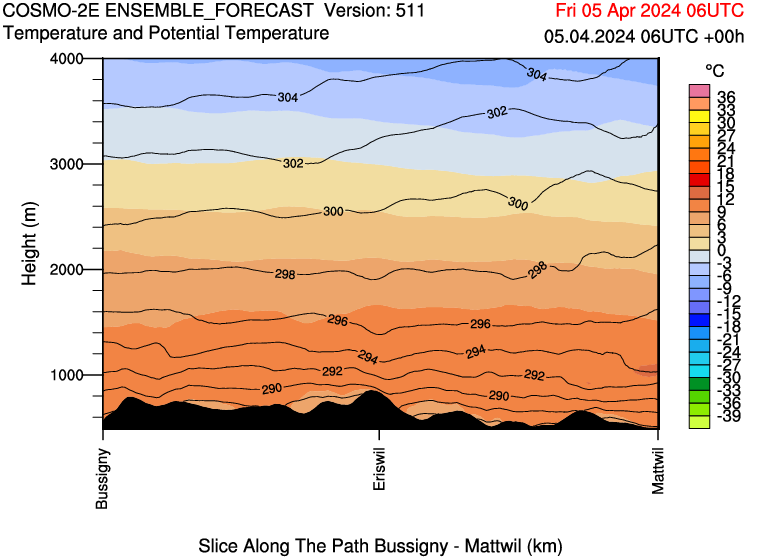
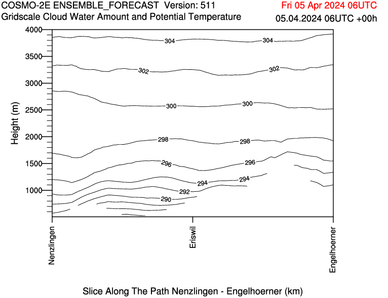
For the CLOUDLAB project we regularly get forecasts that contain a profile at the bottom of the figure from MeteoSwiss that illustrates the terrain nicely (albeit, sometimes it is missing for unknown reasons):
Similarly, I produced a lot of figures of our scans and depending on azimuth and elevation they may be affected by ground clutter, e.g. at a distance of 2 km the increased reflectivity is caused by the terrain below (the hill at around 800 m above sea level). As you can see, I added the terrain already.
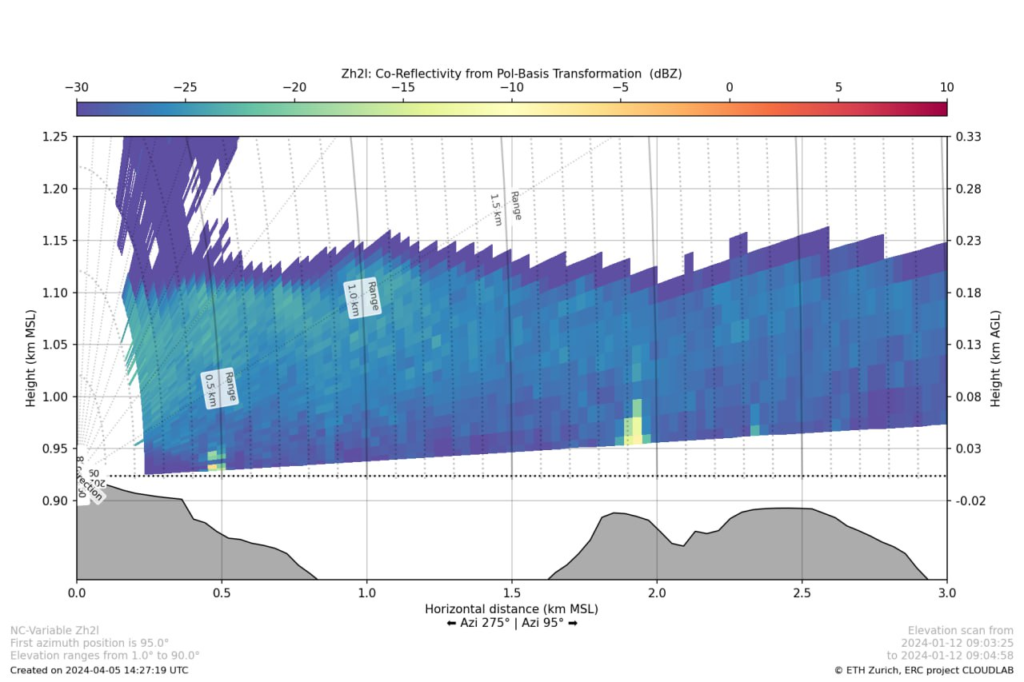
Initially, I thought I’d have to get the actual DEM for the area, find the path matching the scan direction and calculate the profile myself. While this might actually be a bit more accurate with a good DEM, it would be more work, not be transferable and mean I’d have to have extra data around. Instead, I realized that swisstopo offers the measure tool on map.geo.admin.ch and uses their own API with a matching request. So I choose to use this as I’m already adding the coordinates for the scan and it is relatively straightforward (min/max of lowest elevation scanline) to get the path we need. The main issue I faced was a misformatted quote that came from copy-pasting the swisstopo example. After finally figuring this out after a detailed URL decode and string comparison the function is relatively lean and can use either the JSON or the CSV backend of the API and by default gives you out a numpy array which can be visualized with ease and can look as follows:
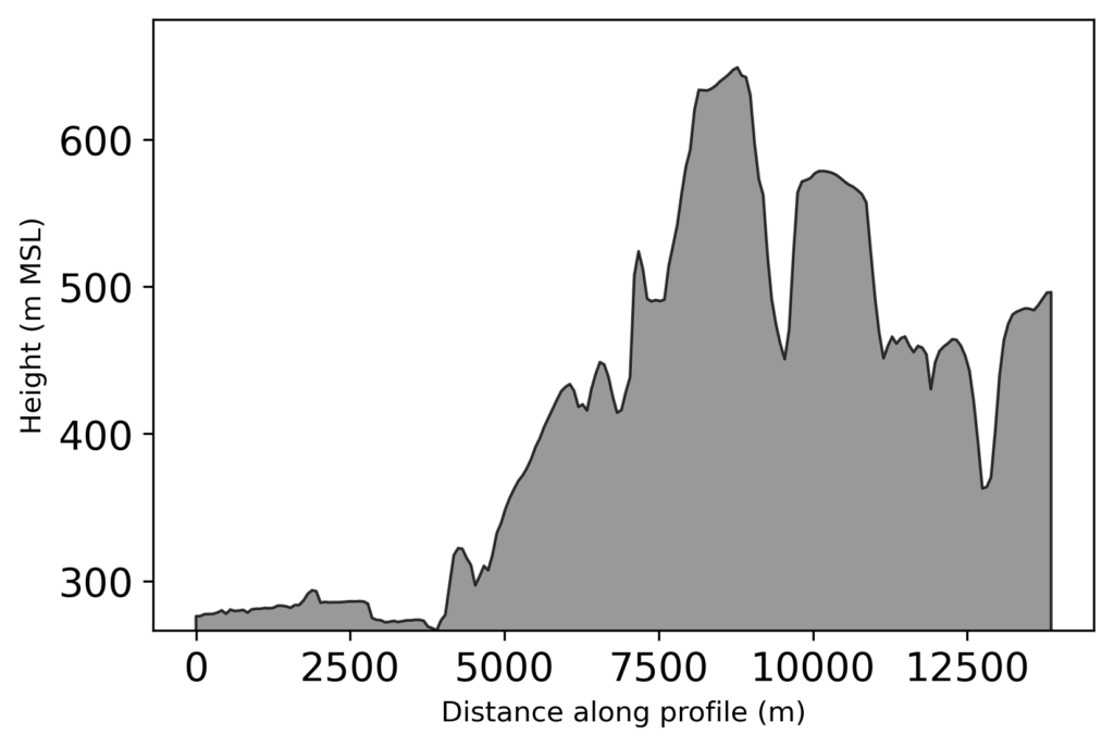
I hope this helps someone to get a profile to enrich their Python (or other) graphs when measuring in Switzerland. In the likely case that you aren’t doing something in Switzerland it might be worthwhile to check out the Google Maps Elevation API (for which you need an API key and billing enabled)
Minor SVG hack
TL;DR; Summary and code
This little script replaces certain properties in an SVG. By default, it only looks first at the file you pass in. Be aware that the wrong replacement can break your SVG. For this reason, the script makes a new SVG by default. As always, the GitHub gist should be the up-to-date version.
Python
#!/usr/bin/env python3
# -*- coding: utf-8 -*-

# ********** Careful, you may break SVG graphics with this************
# ********************** READ THE BELOW FIRST ************************
# ********************** No warranty is taken ************************
# By default nothing other than finding RGB codes in the SVG is done
# and only if you want to change something you can change what you want
# to change (inprop) to what it should be (outprop). For this to work
# set inspect to False.

def svg_property_replacer(file,
                          path='',
                          inspect='rgb',
                          inprop='rgb(0%,0%,0%)',
                          outprop='rgb(100%,0%,0%)',
                          outfile='',
                          force=False):
    import os

    if not outfile:
        outfile = file[:-4]+'_replaced.svg'

    # does the file even exist?
    if not os.path.exists(path+file):
        # answer no, it doesn't, report it, return False
        print('File does not exist')
        return False
    elif not (path+file).endswith('.svg'):
        # answer yes, it does, but isn't an svg, report False
        print('File is not an SVG')
        return False
    else:
        # yes the file exists
        # read the file in
        with open(path+file) as fo:
            img = [line for line in fo.readlines()]

        if 'svg' not in img[0] and 'svg' not in img[1]:
            # it seemed like a svg, but is not a proper one, this may be
            # a mistake by the program that produced it in the first place
            print('Warning! No SVG tag has been found at the start of', file)
            print('For safety reasons only inspection is done.',
                  'Set force to override.')
            print('First lines were', img[0], img[1])
            if not force:
                inspect = 'svg'

        if inspect:
            # look for the inspect string in the lines and print them to stdout
            found = 0
            for _ in img:
                if inspect in _:
                    print(inspect+_.split(inspect)[1].split(';')[0])
                    found = 1
            return found

        else:
            # look for the inprop string in the lines and replace with outprop
            for _ in range(len(img)):
                img[_] = img[_].replace(inprop, outprop)

            # write the outfile as _replaced
            with open(path+outfile, 'w') as fo:
                fo.writelines(img)
        return outfile

if __name__ == '__main__':
    ###### EXAMPLE ######

    # This example turns the SVG into "darkmode", but be careful
    # the results may vary, depending on the original file, i.e. if there is
    # some text in black it'll be white and that may not always make sense
    # the same for big white areas. Just try it out

    path = '~'
    file = 'test.svg'
    file = path+file
    props = [['rgb(0%,0%,0%)','REPLACEMEAGAIN'],
             ['rgb(100%,100%,100%)', 'rgb(0%,0%,0%)'],
             ['REPLACEMEAGAIN', 'rgb(100%,100%,100%)'],
             ['<svg ', '<svg style="background-color: rgb(15%,15%,15%);" '],
             ]

    # file will be named the same with appended _dark
    outfile = file.split('.svg')
    outfile = outfile[0] + '_dark.svg'

    for inprop, outprop in props:
        # make another file first, so we can try out different things
        if [inprop,outprop] == props[0]:
            infile = file
        else:
            # then overwrite the same file always to just have one
            infile = outfile

        svg_property_replacer(infile,
                              outfile=outfile,
                              inprop=inprop,
                              outprop=outprop,
                              inspect=False,
                              )
Background & motivation
Say you have an SVG, either made by yourself, from a colleague or by extracting from a PDF. This is a great starting point and editing vector graphics is often far more comfortable than raster graphics as you won’t have to edit single pixels. Now you could edit this file in Inkscape, illustrator, or any of the many other software solutions. But if all you want to do is change a certain color, or remove some part of the graphics, you can do that without installing any other software. Instead, you can open the SVG file with your text editor of choice and search for the colour you want to replace (note that colours in SVG files are generally in the hexadecimal form, i.e. #RRGGBB, a search for “colour picker” will generally help you figure out what to look for/pick as replacement). It might be a good idea to back up your file beforehand as well. So let’s say you have the following rectangle in your SVG:
<rect
       style="opacity:0.89;fill:#ffffff;stroke-width:0.264583;stroke:#000000;stroke-opacity:1"
       id="rect165"
       width="50"
       height="35"
       x="90"
       y="80" />
This will be a bit transparent, white filled with a black solid border (I added another rectangle just for show):
You can first search for “fill:” or for “stroke:” to see the occurrences of colour uses in your file and in other places. As you can see, it can also be useful and simple to change the opacity or similar by simply editing the file and changing that one value, for example, the red to light blue (replacing #ff0000 with #3399ff):
But most likely you want to do more/change more than one occurrence and/or more than one property. This is where the above script comes in, as you can run it like the example at the bottom of the script and change many properties in a row (note that the REPLACEME is so that we don’t just change everything from white to black and then both previous ones back to black.
Enjoy using it and easily changing your SVGs!
Images to video (sci. vis. util)
TL;DR; Summary & Code
Use the below Python snippet to create an mp4/webm video based on images in a path that all have a prefix (which can be an empty string too of course). It requires you to have setup ffmpeg to be found on the command line (there would be ways to use the Python version too but this way you can also simply create a link to the standalone version if you are on *nix). The gist version on my github should always be up to date.
Python
# -*- coding: utf-8 -*-
"""
At some point in time

@author: elbarto
"""

def img2vid(path,
            prefix,
            moviename='auto',
            movietype='mp4',
            outrate=15,
            inrate=15,
            imgtype='auto',
            width=1280,
            height=960,
            preset='fast',
            quiet=True,
            )
    """
    Create a movie (mp4 or webm) from a series of images from a folder.

    Parameters
    ----------
    path : str
        Where the images are located.
    prefix : str
        The prefix the images have, e.g., img_XX.png
    moviename : str
        The name of the movie that should be written out e.g., img_XX.png
        The default is movie_XX.mp4 where XX is checked avoid overwriting.
    movietype : str
        The format of the movie to be created e.g., mp4 or webm
        The default is mp4, see also parameter moviename.
    outrate : int, optional
        The framerate of the input. The default is 15.
    inrate : int, optional
        The framerate of the output video. The default is 15.
    imgtype : str, optional
        The imagetype to use as input. The default is 'auto',
        which means that jpg, jpeg, png, gif are looked at and collected
    width : int, optional
        The width of the output video. The default is 1280.
    height : int, optional
        The height of the output video. The default is 960.
    preset : str, optional
        The preset for video creation, determining the creation speed.
        The default is 'fast', other options are very_fast, medium, slow...
    quiet : bool, optional
        Whether to print progress to stdout or not. The default is True.

    Returns
    -------
    None.

    """
    import os
    import subprocess

    # cheap implementation of natsort to avoid dependency
    def natsorted(listlike):
        import re
        convert = lambda x: int(x) if x.isdigit() else x.lower()
        alphanum_key = lambda key: [convert(c)
                                    for c in re.split('([0-9]+)', key)]
        return sorted(listlike, key=alphanum_key)

    # for convenience move to the path where the images are located
    # will change at the end to the original path again
    curdir = os.path.abspath(os.curdir)
    os.chdir(path)

    filelist = []

    for entry in os.scandir(path):
        if (not entry.name.startswith('.')
           and entry.is_file()
           and entry.name.startswith(prefix)):
            pass
        else:
            continue

        if imgtype == 'auto':
            imgtypes = ['png', 'jpeg', 'jpg', 'gif']
            chk = [entry.name.lower().endswith(_) for _ in imgtypes]
            if max(chk):
                filelist.append(entry.name)
                _imgtype = [_
                            for _ in imgtypes
                            if entry.name.lower().endswith(_)]
        else:
            if entry.name.lower().endswith(imgtype):
                filelist.append(entry.name)

    filelist = natsorted(filelist)

    if imgtype == 'auto':
        if len(_imgtype) != 1:
            print('Issues with autodetection of image format.',
                  'We found the formats', _imgtype,
                  'Please pass in type directly via imgtype=...')
            return False
        imgtype = _imgtype[0]

    if filelist == []:
        print('No files found with these parameters')

    else:

        if not imgtype.startswith('.'):
            imgtype = '.' + imgtype

        cmd = "ffmpeg -r "
        cmd += f'{inrate} '
        cmd += " -f concat "

        tmpfile = 'temp_filelist.txt'
        with open(path + tmpfile, 'w') as fo:
            for file in filelist:
                fo.writelines('file ' + (file).replace('/', "\\") + '\n')

        cmd += f' -i {tmpfile}'
        cmd += ' -vcodec libx264'
        cmd += f' -preset {preset} '
        cmd += '-pix_fmt yuv420p -r '
        cmd += str(outrate)
        cmd += ' -y -s ' + f'{width}x{height} '

        # may be an issue if you have 1382195208752376502350 movie files in
        # the same folder which we hope is unlikely!
        startnumber = 0
        while os.path.exists(path+f'movie_{startnumber}.mp4'):
            startnumber += 1

        if moviename == 'auto':
            moviename = (f'movie_{startnumber}.{movietype}').replace('/', os.sep)

        cmd += moviename

        try:
            if not quiet:
                print('Calling', cmd)
            subprocess.check_call(cmd.split())
            print(f'Successfully made movie {path+os.sep + moviename}')
        except subprocess.CalledProcessError:
            print('Calling ffmpeg failed!',
                  'Make sure it is installed on your system via conda/pip/...')
        finally:
            pass
            os.chdir(curdir)
            os.remove(tmpfile)

        return path + os.sep + moviename
Background & motivation
Who doesn’t know it? You have to give a talk, illustrate your findings or simply want to show something extra on your poster at a conference with a tablet or linked via QR code. Now you can upload your image sequence to many online pages that will convert it into a format of your choice. After you made the video, you notice a mistake in the images and you have to redo it – maybe more than once even. If you want several videos, repeat the process even more often.
Instead, you could use video software suites that render the images into videos, but this is essentially the same tedious process and often requires you to learn the software (which has its own merit but maybe you are lacking the time). Why not program it instead?
The requirements are actually quite easy to meet, especially if we are using ffmpeg and Python. This requires you to have setup ffmpeg so it can be found on the command line.
Development process
To simplify the process, let’s look at the requirements for the function that were important for me at the time:
- Call ffmpeg on the command line
- Name the movie and do not overwrite existing movies
- Pass in a path of images or a list of files (handy if you store the output from another script)
- Which kind of move to make (mp4 usually is compatible the most, but webm is also useful when making videos for the web/browsers – I tend to go with mp4 for powerpoint presentations, but webm is also supported by MS Office 365 nowadays)
- How fast the movie should play (in/outrate)
- Which image type the images are (read jpeg, jpg, png gif are fine)
- The dimensions the video should have (width, height), per default the first image dimension is taken
- How the rendering by ffmpeg should be done (fast is usually good enough quality, there is a tradeoff, see documentation of ffmpeg)
- Whether to report some progress during the making – aka the quiet option
Some things to consider are:
- You could use natsorted, to get a natural sort of the files as that is usually how we humans would sort them. Usually, this makes little difference but natural sorting works better with mixed naming conventions (0001, 0010, 0100 … vs 1, 10, 100 …). Instead of another dependency, a cheap natsort is implemented as well. Replace the function if you actually have natsort installed and want to use it instead.
- Instead you can also directly run the video command via ffmpeg on the command line – this is just a thin wrapper to keep some default options in place that made sense to me. You could also write files out to a file and load them via ffmpeg instead …
Other than that, the process is straightforward. Pass in your directory and the prefix that the images might have (tune some things if you want to). Otherwise, enjoy your video making and as a teaser, the following timelapse is made via the above script on a regular basis and linked here
Further reading and resources
- Gist of relevant code https://gist.github.com/spirrobe/48f8c8fa033957f0f9798f085835bf22
- ffmpeg website ffmpeg.org
Basel linked data
TL;DR; Get population data of the neighbourhoods of Basel
The following SPARQL query allows you to receive the population data from the linked data platform of the city of Basel at a really fine resolution in terms of age.
Basel Stadt publishes many of their dataset (“open by default”), for example, those presented on the “Basler Atlas“. As we’ve seen in another post we can use webscrapping to download them for further analysis. However, one downside if that the data are already aggregated to some extent or grouped (e.g. 0-24, 25-64, 65 – for age, or into gender). This limits a potential analysis to these criteria and means we cannot do a demographic display.
However, I realized that Basel-Stadt is offering also a linked data site (based on the same techstack as LINDAS that I showcased with regards to current hydrodata). Within, you can get some observation sets:
Linked data (Python/LINDAS/SPARQL/hydrodata)
TL;DR;
Make a map of the original and/or fixed coordinates of the hydrological stations of the BAFU using the data from Lindas

The above map is an illustration of the data we can extract with use of a SPARQL query and lindas of the hydrological data published on it. As you can see, there are two sets of points, one in Switzerland (corrected version) and one in the Mediterranean based on the “raw” lindas data (400km offset for some reason).
In my last post, I wanted to see how to get the current data of waterbodies from lindas.admin.ch in one table including geometry information. Now, we of course want to use Python to investigate the data; additionally, we want to extend our existing hydrodata SPARQL query to handle also a subset of stations instead of all stations.
import datetime
import requests
import pandas as pd
import numpy as np
import matplotlib.pyplot as plt


# The prefixes, mainly to have them seperate
PREFIXES = """
PREFIX schema: <http://schema.org/>
PREFIX hg: <http://rdf.histograph.io/>
PREFIX la: <https://linked.art/ns/terms/>
PREFIX ex: <http://example.org/>

# hydro related prefixes
PREFIX h: <https://environment.ld.admin.ch/foen/hydro/>
PREFIX hd: <https://environment.ld.admin.ch/foen/hydro/dimension/>
PREFIX hgs: <https://environment.ld.admin.ch/foen/hydro/station/>
PREFIX river: <https://environment.ld.admin.ch/foen/hydro/river/observation/>
PREFIX lake: <https://environment.ld.admin.ch/foen/hydro/lake/observation/>

# geo related prefixes
PREFIX wkt: <http://www.opengis.net/ont/geosparql#asWKT>

# hydrodata related prefixes (fake) that we use to reference to the historical data. haha.
PREFIX hydrodata: <https://www.hydrodaten.admin.ch/plots/>

"""


## a function that makes the response to a dataframe, tailored to the hydrodata
# and that also contains a small validation step to remove "outdated" values
def _response2dataframe(response,
                        validate=True,
                        time_threshold=datetime.timedelta(minutes=30)):
    # return pd.read_csv(io.StringIO(resp.text))
    data = response.text.strip().split('\n')
    columns = data[0].split(',')
    data = [i.strip().split(',') for i in data[1:]]
    index = [i[0] for i in data]
    ix = columns.index('data')
    values = [[i[0]] + i[ix].split(';') for i in data]
    data = [[j for _, j in enumerate(i) if _ != ix]
            for i in data]
    # the dataframe holding all non measurement values
    columns.pop(ix)
    data1 = pd.DataFrame(columns=columns,
                        data=data,
                        index=index)

    for col in data1.columns:
        data1[col] = pd.to_numeric(data1[col], errors='ignore')

    def _list2dict(datalist):
        return {i: j for i, j in zip(datalist[::2], datalist[1::2])}
    values = {i[0]: _list2dict(i[1:])
              for i in values}
    ix = values.keys()
    columns = []

    for i in values.items():

        vartypes = list(i[1].keys())

        for vartype in vartypes:
            if vartype in columns:
                pass
            else:
                columns.append(vartype)
    data = [[] for i in columns]

    for i in ix:
        for colno, colname in enumerate(columns):
            value = values[i][colname] if colname in values[i].keys() else ''
            data[colno].append(value)
    data = np.transpose(data)

    data2 = pd.DataFrame(columns=columns, data=data, index=ix)
    for col in data2.columns:
        if col != 'measurementTime':
            data2[col] = pd.to_numeric(data2[col], errors='coerce')

    data = pd.concat([data1, data2], axis=1)
    data['query_time'] = pd.to_datetime(data['query_time'])
    data['measurementTime'] = pd.to_datetime(data['measurementTime'])

    if validate:
        time_threshold = pd.to_timedelta(time_threshold)
        good = data['query_time'] <= data['measurementTime'] + time_threshold
        # for illustration
        bad = data['query_time'] >= data['measurementTime'] + time_threshold
        data['measurementAge'] = data['query_time'] - data['measurementTime']
        data = data[good]
    return data


def get_hydrodata(station_ids=None,
                  return_as_dataframe=True,
                  validate=True,
                  time_threshold=datetime.timedelta(minutes=30)):
    query = [
        """# what we want to get out of the query as "nicely" formatted data
       SELECT ?station_id ?station_name ?station_type ?station_type_nice
              ?latitude ?longitude ?station_iri ?station_data_iri ?station_geometry_iri
              (group_concat(?measurement_type_measurement_value;SEPARATOR=";") as ?data)
              ?query_time
              # add the https://hydrodaten.admin.ch url for the data that go back 7 days (actually 40 days sometimes, see dev console)
             (if(contains(?data,"discharge"), uri(concat(str(hydrodata:), 'p_q_7days/', ?station_id, '_p_q_7days_de.json')), "")
              as ?hydrodata_url_discharge_waterlevel)
             (if(contains(?data,"temp"), uri(concat(str(hydrodata:), 'temperature_7days/', ?station_id, '_temperature_7days_de.json')), "")
              as ?hydrodata_url_temperature)
       """
        # where part including initial setup of measurement types
        """
          WHERE { ?station ?prop ?value.
                 filter( ?prop in (ex:isLiter, hd:measurementTime, hd:waterTemperature,  hd:waterLevel, hd:discharge))
        """,
        # generating data and variables part
        """
        bind(replace(replace(
             str(?station), str(river:), "", "i"),
             str(lake:), "", "i")
            as ?station_id)
        # the above is equivalent to this in theory but the above uses prefixes so would be easier to change
        # in case of changes
        # bind(strafter(str(?station), "observation/") as ?station_id2)
        # get the kind of station this is (whether lake or river) - the hierarchy/ontology here is weird as all are measurement stations
        # or observation but the distinction is river/lake first then observation
        bind(strbefore(strafter(str(?station), str(h:)), "/") as ?station_type)
        # uppercase the first letter -> why is there no capitalize function in SPARQL :throw_table:
        bind(concat(ucase(substr(?station_type,1,1)), substr(?station_type,2,strlen(?station_type)-1)) as ?station_type_nice)
        # remove some filler words from the data
        bind(replace(str(?prop), str(hd:), "", "i") as ?measurement_type)
        # convert the actual measurement value to a literal
        bind(str(?value) as ?measurement_value)
        # introduce the time of the query to (maybe) see if the values are old
        bind( str(now()) as ?query_time)
        # combine the type of measurement with the value so we can group by and not loose information
        bind(concat(?measurement_type, ';', ?measurement_value, '') as ?measurement_type_measurement_value)

        # start making IRIs so we can check/link back to lindas
        # the IRI containing information of the station itself (not linked to river/lake)
        bind(IRI(concat(str(hgs:), ?station_id)) as ?station_iri)
        # generate the geometry IRI
        bind(IRI(concat(str(hgs:), concat(?station_id,"/geometry"))) as ?station_geometry_iri)
        # generate the station IRI that holds the data information
        bind(IRI(concat(str(h:), ?station_type, "/observation/", ?station_id)) as ?station_data_iri)
        # get the information about the location of the station
        ?station_geometry_iri wkt: ?coordinates.
        # also get the name
        ?station_iri schema:name ?stat_name.
        bind(replace(?stat_name, ',', ';') as ?station_name)

        # simplifiy the geometry to lon/lat in array form
        BIND(STRBEFORE(STRAFTER(STR(?coordinates), " "), ")") AS ?latitude)
        BIND(STRBEFORE(STRAFTER(STR(?coordinates), "("), " ") AS ?longitude)
    }""",

    # grouping part
    """
    group by # the station information
    ?station_id ?station_type ?station_type_nice ?station_name
    ?latitude ?longitude
    # the IRIs
    ?station_iri ?station_data_iri ?station_geometry_iri
    # validation information
    ?query_time
    """,
    # sorting part
    """
    order by ?station_id
    """

    ]
    if station_ids is not None:
        # per default, get all stations but if some stations are given uses
        # this modication instead
        station_ids = station_ids if isinstance(
            station_ids, list) else list(station_ids)

        station_ids = '"' + '","'.join([str(i) for i in station_ids]) + '"'
        query.insert(1, f'filter (?station_id in ({station_ids}))')

    query = PREFIXES + '\n'.join(query)
    resp = requests.post("https://ld.admin.ch/query",
                         data="query=" + query,
                         headers={
                             "Content-Type": "application/x-www-form-urlencoded; charset=utf-8",
                             "Accept": "text/csv"
                         }
                         )

    resp.encoding = "utf-8"

    if return_as_dataframe:
        resp = _response2dataframe(resp,
                                   validate=validate,
                                   time_threshold=time_threshold)

    return resp, query

if __name__ == '__main__':
    df, query = get_hydrodata()
    subset = [2091, 2613]
    df_subset, query_subset = get_hydrodata(station_ids=subset,
                                            return_as_dataframe=True)
A first approach is given by the lindas help which showcases the use of the typical request together with pandas. The example is straightforward but not usually how we’ll have data (more than 3 columns ..) that are useful with pandas. As we’ve seen in the last exploration of lindas, we can write a query that gives us a row for each station of the hydrological network of the BAFU. To be consistent with the example, we want a CSV return, which means replacing all commas with something better (especially the names of stations sometimes do have a comma inside). Other than that, the query that we used before also works directly via Python and we only extended it with the option to additionally filter with station_ids by adding the below (which adds a very simple filter into the query):
    if station_ids is not None:
        # per default, get all stations but if some stations are given uses
        # this modication instead
        station_ids = station_ids if isinstance(
            station_ids, list) else list(station_ids)

        station_ids = '"' + '","'.join([str(i) for i in station_ids]) + '"'
        query.insert(1, f'filter (?station_id in ({station_ids}))')
Additionally, as I didn’t manage to split the values again into separate columns after the grouping (or only with a lot of needless wordiness), I wrote a small converter function that mainly extracts the general information (meta-information if you will like latitude/longitude or similar) and converts the actual measurement data into columns and concatenates the two.
## a function that makes the response to a dataframe, tailored to the hydrodata
# and that also contains a small validation step to remove "outdated" values
def _response2dataframe(response,
                        validate=True,
                        time_threshold=datetime.timedelta(minutes=30)):
    # return pd.read_csv(io.StringIO(resp.text))
    data = response.text.strip().split('\n')
    columns = data[0].split(',')
    data = [i.strip().split(',') for i in data[1:]]
    index = [i[0] for i in data]
    ix = columns.index('data')
    values = [[i[0]] + i[ix].split(';') for i in data]
    data = [[j for _, j in enumerate(i) if _ != ix]
            for i in data]
    # the dataframe holding all non measurement values
    columns.pop(ix)
    data1 = pd.DataFrame(columns=columns,
                        data=data,
                        index=index)

    for col in data1.columns:
        data1[col] = pd.to_numeric(data1[col], errors='ignore')

    def _list2dict(datalist):
        return {i: j for i, j in zip(datalist[::2], datalist[1::2])}
    values = {i[0]: _list2dict(i[1:])
              for i in values}
    ix = values.keys()
    columns = []

    for i in values.items():

        vartypes = list(i[1].keys())

        for vartype in vartypes:
            if vartype in columns:
                pass
            else:
                columns.append(vartype)
    data = [[] for i in columns]

    for i in ix:
        for colno, colname in enumerate(columns):
            value = values[i][colname] if colname in values[i].keys() else ''
            data[colno].append(value)
    data = np.transpose(data)

    data2 = pd.DataFrame(columns=columns, data=data, index=ix)
    for col in data2.columns:
        if col != 'measurementTime':
            data2[col] = pd.to_numeric(data2[col], errors='coerce')

    data = pd.concat([data1, data2], axis=1)
    data['query_time'] = pd.to_datetime(data['query_time'])
    data['measurementTime'] = pd.to_datetime(data['measurementTime'])

    if validate:
        time_threshold = pd.to_timedelta(time_threshold)
        good = data['query_time'] <= data['measurementTime'] + time_threshold
        # for illustration
        bad = data['query_time'] >= data['measurementTime'] + time_threshold
        data['measurementAge'] = data['query_time'] - data['measurementTime']
        data = data[good]
    return data
Additionally, we can fix the offset that we found (~400 km in latitude) in the geometry by using the following (after importing my conversion functions):
rw, hw = wgs84_to_ch1903(df['latitude'], df['longitude'])
hw = hw + 400000
lat, lon = ch1903_to_wgs84(hw, rw)
Now we can see the difference, especially when we plot the dataframe of water temperatures (the labelling is really overkill at this point and just for illustration):
## fix the offset

hw, rw = wgs84_to_ch1903(df['latitude'], df['longitude'], plus=True)
hw = hw + 400000
lat, lon = ch1903_to_wgs84(hw, rw)


# setup the map
import cartopy.crs as ccrs
import cartopy.feature as cf
fig, ax = plt.subplots(dpi=200, figsize=[9, 9], subplot_kw={"projection":ccrs.PlateCarree()})
thevar = 'waterTemperature'
units = {'waterLevel': 'm MSL', 'waterTemperature': '°C', 'discharge': 'm³/s'}

# show the "original" coordinates
s = ax.scatter(df['longitude'], df['latitude'], s=150, edgecolor='k', c=df[thevar], vmin=0, vmax=25, cmap='coolwarm')
# show the fixed coordinates
s = ax.scatter(lon, lat, s=150, edgecolor='k', c=df[thevar], cmap='coolwarm', vmin=0, vmax=25)

# the respective name of the station as label if need be
add_station_label = False
if add_station_label:
    for sid, thevalue, lon, lat, station_name in zip(df['station_id'], df[thevar], df['longitude'], df['latitude'], df['station_name']):
        if np.isnan(thevalue):
            continue
        ax.text(lon, lat, station_name.replace(';','\n').replace(' ','\n'), va='center', ha='center', fontsize=3, clip_on=True)

# map decorations
ax.set_xlabel('Longitude (°)')
ax.set_ylabel('Latitude (°)')
plt.colorbar(s, aspect=50, pad=0.1, location='bottom', label=f'{thevar.replace("water","").capitalize()}'+f' ({units[thevar]})')
ax.set_title(f'Hydrodata in Switzerland')
ax.gridlines(draw_labels=True, dms=True, x_inline=False, y_inline=False, lw=0.25, color='k')
# if you want, add a stockimage but it won't look nice at this resolution
#ax.stock_img()

# add coastline and borders to illustrate
ax.coastlines()
ax.add_feature(cf.BORDERS)
# set proper boundaries for illustration
ax.set_ylim(42, 48)
ax.set_xlim(5, 12)
If you wish instead to only plot data points that have a valid temperature you can use the condition notnull() on the variable:
# fix the offset
hw, rw = wgs84_to_ch1903(df['latitude'], df['longitude'], plus=True)
hw = hw + 400000
lat, lon = ch1903_to_wgs84(hw, rw)

# setup the map

fig, ax = plt.subplots(dpi=200, figsize=[16, 12], subplot_kw={"projection":ccrs.PlateCarree()})
thevar = 'waterTemperature'
units = {'waterLevel': 'm MSL', 'waterTemperature': '°C', 'discharge': 'm³/s'}

# filter out stations without values for this variable
cond = df[thevar].notnull()
# show the "original" coordinates
s = ax.scatter(df['longitude'][cond], df['latitude'][cond], s=150, edgecolor='k', c=df[thevar][cond], vmin=0, vmax=25, cmap='coolwarm')
# show the fixed coordinates
s = ax.scatter(lon[cond], lat[cond], s=150, edgecolor='k', c=df[thevar][cond], cmap='coolwarm', vmin=0, vmax=25)

# map decorations
ax.set_xlabel('Longitude (°)')
ax.set_ylabel('Latitude (°)')
plt.colorbar(s, aspect=50, pad=0.1, location='bottom', label=f'{thevar.replace("water","").capitalize()}'+f' ({units[thevar]})')
ax.set_title(f'Hydrodata of Switzerland')
ax.gridlines(draw_labels=True, dms=True, x_inline=False, y_inline=False, lw=0.25, color='k')

# if you want, add a stockimage but it won't look nice at this resolution
#ax.stock_img()

# add coastline and borders to illustrate
ax.coastlines()
ax.add_feature(cf.BORDERS)

# set proper boundaries for illustration
ax.set_ylim(45.5, 48)
ax.set_xlim(5.5, 11)
Going forward, you could use requests to download the past measurement data that are linked in the dataframe via the query (hydrodata URL) and make an animation; probably xarray would be a better choice for holding the data then though…
Hope this was interesting on how to combine and going forward we’ll look at using openlayers and the JSON response from lindas to make a map.
PS: On another note, while we found an offset last time, there is one station in the dataset that has a wrong longitude as well, the station with id 2270 “Combe des Sarrasins” with latitude of 41.315… and longitude of 0.296… according to its lindas entry but should really be at 47.195… , 6.877…
Linked data (LINDAS/SPARQL/hydrodata)
TL;DR;
Get the up-to-date data from LINDAS of the currently available values discharge / water level/water temperatures for all BAFU stations.
PREFIX schema: <http://schema.org/>
PREFIX hg: <http://rdf.histograph.io/>
PREFIX la: <https://linked.art/ns/terms/>
prefix ex: <http://example.org/>

# hydro related prefixes
prefix h: <https://environment.ld.admin.ch/foen/hydro/>
prefix hd: <https://environment.ld.admin.ch/foen/hydro/dimension/>
prefix hgs: <https://environment.ld.admin.ch/foen/hydro/station/>
prefix river: <https://environment.ld.admin.ch/foen/hydro/river/observation/>
prefix lake: <https://environment.ld.admin.ch/foen/hydro/lake/observation/>

# geo related prefixes
prefix wkt: <http://www.opengis.net/ont/geosparql#asWKT>

# hydrodata related prefixes (fake) that we use to reference to the historical data.
prefix hydrodata: <https://www.hydrodaten.admin.ch/plots/>


# what we want to get out of the query as "nicely" formatted data
SELECT ?station_id ?station_name ?station_type ?station_type_nice
    ?latitude ?longitude
    ?station_iri ?station_data_iri ?station_geometry_iri
	  (group_concat(?measurement_type_measurement_value;SEPARATOR=";") as ?data)
		#?hydrodata_url_temperature ?hydrodata_url_discharge_waterlevel
		?query_time
		# add the https://hydrodaten.admin.ch url for the data that go back
		# 7 days (actually 40 days sometimes, see dev console)
  		(if(contains(?data,"discharge"),
  		    uri(concat(str(hydrodata:), 'p_q_7days/',
  		               ?station_id, '_p_q_7days_de.json')),
          "")
    		as ?hydrodata_url_discharge_waterlevel)
        (if(contains(?data,"temp"),
            uri(concat(str(hydrodata:), 'temperature_7days/',
                ?station_id, '_temperature_7days_de.json')),
           "")
    	as ?hydrodata_url_temperature)

where {
  		# it seems counterintuitive but getting everything and filtering
  		# is faster than first getting
  		# the stationlist and go trough their IRI
        ?station ?prop ?value.
  		# we only want to keep actual data variables and time
        filter( ?prop in (ex:isLiter, hd:measurementTime, hd:waterTemperature,  hd:waterLevel, hd:discharge))
  		# convert the subject station to the id, which is the last thing after the /;
  		bind(replace(replace(
        	str(?station), str(river:), "", "i"),
      		str(lake:), "", "i")
    		as ?station_id)
  		# the above is equivalent to this in theory but the above
  		# uses prefixes so would be easier to change
		# in case of changes
  		#bind(strafter(str(?station), "observation/") as ?station_id2)
  		# get the kind of station this is (whether lake or river)
  		# - the hierarchy/ontology here is weird as all are measurement stations
		# or observation but the distinction is river/lake first then observation
  		bind(strbefore(strafter(str(?station), str(h:)), "/") as ?station_type)
  		# uppercase the first letter -> why is there no capitalize function in SPARQL
  		bind(concat(ucase(substr(?station_type,1,1)), substr(?station_type,2,strlen(?station_type)-1)) as ?station_type_nice)
  		# remove some filler words from the data
		bind(replace(str(?prop), str(hd:), "", "i") as ?measurement_type)
  		# convert the actual measurement value to a literal
        bind(str(?value) as ?measurement_value)
  		# introduce the time of the query to (maybe) see if the values are old
        bind( str(now()) as ?query_time)
  		# combine the type of measurement with the value so we
  		# can group by and not loose information
  		bind(concat(?measurement_type, ';', ?measurement_value, '') as ?measurement_type_measurement_value)

  		# start making IRIs so we can check/link back to lindas
  		# the IRI containing information of the station itself (not linked to river/lake)
  		bind(IRI(concat(str(hgs:), ?station_id)) as ?station_iri)
  		# generate the geometry IRI
  		bind(IRI(concat(str(hgs:), concat(?station_id,"/geometry"))) as ?station_geometry_iri)
  		# generate the station IRI that holds the data information
  		bind(IRI(concat(str(h:), ?station_type, "/observation/", ?station_id)) as ?station_data_iri)
  		# get the information about the location of the station
  		?station_geometry_iri wkt: ?coordinates.
  		# also get the name and remove commas to not confuse them with seps
      ?station_iri schema:name ?stat_name.
      bind(replace(?stat_name, ',', ';') as ?station_name)

  		# simplifiy the geometry to lon/lat in array form
        BIND(STRBEFORE(STRAFTER(STR(?coordinates), " "), ")") AS ?latitude)
        BIND(STRBEFORE(STRAFTER(STR(?coordinates), "("), " ") AS ?longitude)


}
# group by, basically keep everything of the select here
# except the ?measurement_type_measurement_value which we want to combine to one row
# (ideally we would actually get them as seperate columns again but this seems the best we can do for the moment
group by # the station information
		?station_id ?station_type ?station_type_nice ?station_name
		?latitude ?longitude
		# the IRIs
		 ?station_iri ?station_data_iri ?station_geometry_iri
		# validation information
		 ?query_time
This one took quite some time and serves as of now not much purpose other than training SPARQL for me. Essentially, I was asked once to use “the API” for the current water temperatures that are embedded in my RaspberryPI webcams.
Now, initially I actually “webscapped” the JSON data from hydrodata and transferred them to the MCR database as this allowed the concurrent use of in-house data with the BAFU data. Additionally, the urban/rural/water temperature graph of dolueg2 uses exactly the same temperature, meaning it makes sense to keep it in the same database (at least for some of the relevant stations around Basel, the B2091 means BAFU station 2091).
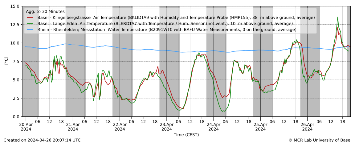
Now going back to “the API” and RDF where data are in triplet form (subject property object) to allow reuse and linking we can get the most recent data of any of the BAFU stations, via e.g.
prefix hd: <https://environment.ld.admin.ch/foen/hydro/dimension/>
SELECT * WHERE {
  <https://environment.ld.admin.ch/foen/hydro/river/observation/2091> hd:waterTemperature ?obj .
}
# see also the page: https://environment.ld.admin.ch/foen/hydro/river/observation/2091
or some relevant values for us (more than water temperature)
prefix hd: <https://environment.ld.admin.ch/foen/hydro/dimension/>
prefix obs: <https://environment.ld.admin.ch/foen/hydro/river/observation/>


SELECT * WHERE {
  obs:2091 ?prop ?obj .
  filter( ?prop in (hd:measurementTime, hd:waterTemperature,  hd:waterLevel, hd:discharge))

}
The above is an excerpt of the output from the LINDAS SPARQL endpoint at the time of writing. Notably, we can also get the information for the station (note the added prefix):
prefix station: <https://environment.ld.admin.ch/foen/hydro/station/>
SELECT * WHERE {
  station:2091 ?prop ?obj .
}
And as you can see, there is also a geometry linked to the station data (shown without query this time):
Cool – except for the fact that the southernmost point of Switzerland is located at 45°49’N. And the station in question (id 2091) is in Rheinfelden, i.e. in the North of Switzerland. So something seems off here and I informed the responsible person in the hopes that they’ll fix that soon.
Now, initially, I thought I’d first extract the IDs of the relevant station, then get their properties of interest/values but somehow the query runs rather slow (6+ seconds); probably this could be fixed and if someone wants to try, the following should give a nicely formatted data table (I actually assume that eventually the trigger for measurement time might not be a good choice when more and more datasets would be available on LINDAS):
PREFIX rdf: <http://www.w3.org/1999/02/22-rdf-syntax-ns#>
PREFIX rdfs: <http://www.w3.org/2000/01/rdf-schema#>
PREFIX xsd: <http://www.w3.org/2001/XMLSchema#>
# hydro related prefixes
prefix h: <https://environment.ld.admin.ch/foen/hydro/>
prefix hd: <https://environment.ld.admin.ch/foen/hydro/dimension/>
prefix hydro_geo: <https://environment.ld.admin.ch/foen/hydro/station/>
# geo related prefixes
prefix wkt: <http://www.opengis.net/ont/geosparql#asWKT>

select ?station_iri ?station_id ?station_type ?coordinates ?station_coordinates ?query_time ?measurement_time ?waterTemperature ?discharge ?waterLevel
where {

    ?station hd:measurementTime ?measurement_time.
    optional {?station hd:waterLevel ?waterLevel. }
    optional { ?station hd:discharge ?discharge.}
  	optional { ?station hd:waterTemperature ?waterTemperature.}
  # measurement related things
  bind(now() as ?query_time)
  bind(strbefore(strafter(str(?station), str(h:)), "/") as ?station_type)
  bind(strafter(str(?station), "observation/") as ?station_id)
  # geo related things
  # first find all the relevant subjects, i.e. station property pages
  bind(IRI(concat(str(hydro_geo:), concat(?station_id,"/geometry"))) as ?station_geometry_iri)
  bind(IRI(concat(str(hydro_geo:), ?station_id)) as ?station_iri)
  ?station_geometry_iri wkt: ?coordinates.
  BIND(strafter(strbefore(str(?coordinates),")"), "POINT(") AS ?station_coordinates)
  # can be used for yasgui and nicer representation but slows the query
  #bind(xsd:decimal(?station_id) as ?station_id_numeric)
}
#order by desc(?station_id_numeric)

As you can see, it’s important to use the OPTIONAL keyword as not all stations have all variables (water temperature / discharge / level). Additionally, I retrieve the kind of station (lake/river) that is available. The choice of prefix for these is a bit weird for my feeling as the hierarchy seems to be river/lake then station instead of the other way around – which must have a reason that I’m too inexperienced to understand. The rest of the query is cosmetics to get a bit nicer values (keep the geometry as proper type and you can get a map of the observations though).
As seen, this runs rather slow (6+ seconds for around 230 records is too slow on any day) so I started experimenting, arriving ultimately at the code at the top (here shortened to remove geometry and hydrodata links) by first filtering out the relevant dimensions, essentially getting the data first, then cleaning up a bit and concatenating by station id.
PREFIX schema: <http://schema.org/>
PREFIX hg: <http://rdf.histograph.io/>
PREFIX la: <https://linked.art/ns/terms/>
prefix ex: <http://example.org/>

# hydro related prefixes
prefix h: <https://environment.ld.admin.ch/foen/hydro/>
prefix hd: <https://environment.ld.admin.ch/foen/hydro/dimension/>
prefix hgs: <https://environment.ld.admin.ch/foen/hydro/station/>
prefix river: <https://environment.ld.admin.ch/foen/hydro/river/observation/>
prefix lake: <https://environment.ld.admin.ch/foen/hydro/lake/observation/>

# geo related prefixes
prefix wkt: <http://www.opengis.net/ont/geosparql#asWKT>


# what we want to get out of the query as "nicely" formatted data
SELECT ?station_id ?station_name ?station_type ?station_type_nice ?station_iri ?station_data_iri
	  (group_concat(?measurement_type_measurement_value;SEPARATOR=", ") as ?data)
		#?hydrodata_url_temperature ?hydrodata_url_discharge_waterlevel
		?query_time
where {
  		# it seems counterintuitive but getting everything and filtering is faster than first getting
  		# the stationlist and go trough their IRI
        ?station ?prop ?value.
  		# we only want to keep actual data variables and time
        filter( ?prop in (hd:measurementTime, hd:waterTemperature,  hd:waterLevel, hd:discharge))
  		# convert the subject station to the id, which is the last thing after the /;
  		bind(replace(replace(
        	str(?station), str(river:), "", "i"),
      		str(lake:), "", "i")
    		as ?station_id)
  		# the above is equivalent to this in theory but the above uses prefixes so would be easier to change
		# in case of changes
  		#bind(strafter(str(?station), "observation/") as ?station_id2)
  		# get the kind of station this is (whether lake or river) - the hierarchy/ontology here is weird as all are measurement stations
		# or observation but the distinction is river/lake first then observation
  		bind(strbefore(strafter(str(?station), str(h:)), "/") as ?station_type)
  		# uppercase the first letter -> why is there no capitalize function in SPARQL (╯°□°)╯︵ ┻━┻
  		bind(concat(ucase(substr(?station_type,1,1)), substr(?station_type,2,strlen(?station_type)-1)) as ?station_type_nice)
  		# remove some filler words from the data
		bind(replace(replace(replace(
            str(?prop), str(hd:), "", "i"),
            "water", "", "i"),
            "measurementTime", "measurement_time", "i")
            as ?measurement_type)
  		# convert the actual measurement value to a literal
        bind(str(?value) as ?measurement_value)
  		# introduce the time of the query to (maybe) see if the values are old
        bind( str(now()) as ?query_time)
  		# combine the type of measurement with the value so we can group by and not loose information
  		bind(concat(?measurement_type, ': ', ?measurement_value, '') as ?measurement_type_measurement_value)

  		# start making IRIs so we can check/link back to lindas
  		# the IRI containing information of the station itself (not linked to river/lake)
  		bind(IRI(concat(str(hgs:), ?station_id)) as ?station_iri)


}
# group by, basically keep everything of the select here
# except the ?measurement_type_measurement_value which we want to combine to one row
# (ideally we would actually get them as seperate columns again but this seems the best we can do for the moment
group by # the station information
		?station_id ?station_type ?station_type_nice ?station_name
		# the IRIs
		 ?station_iri ?station_data_iri
		# validation information
		 ?query_time
This query is the reduced version of the one on top. It runs in around 1 second or less and can now be used for automated queries or other products as described here on LINDAS. The only additions are the added geometry and the URLs for the hydrodata website that give you the historical data to implement a product I have in mind that might come up later. And maybe at some point, we can also get data from the past on LINDAS, making the project I have in mind easier.
Update:
The offset in the geometry seems to be consistently 400’000 m in “hochwert”/latitude based on three stations picked from hydrodata and LINDAS where longitude is almost correct:
b = 2634026 , 1125901 # 2531
a = 7.854351126515431, 42.67878915566025 # 2531
a = wgs84_to_ch1903(*a[::-1], plus=True)[::-1]
print([i - j for i, j in zip(a, b)])
#out: [132.7675012690015, -401020.22037598956]

b = 2627189 , 1267845 # 2091
a = 7.777036377264884, 43.96335989872657 # 2091
a = wgs84_to_ch1903(*a[::-1], plus=True)[::-1]
print([i - j for i, j in zip(a, b)])
#out: [1.471713425591588, -399994.8737920185]

b = 2830800 , 1168706 # 2617
a = 10.265672193049967, 43.036021653211186 # 2617
a = wgs84_to_ch1903(*a[::-1], plus=True)[::-1]
print([i - j for i, j in zip(a, b)])
#out: [48.71478863572702, -399969.5114403835]