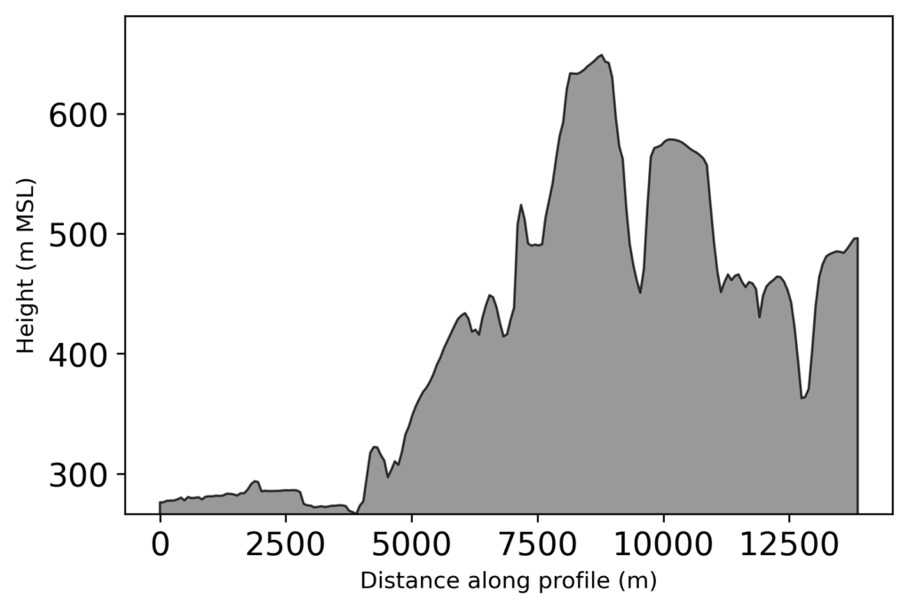
Use the swisstopo API to get a profile of altitudes with the function get_swisstopo_elevation_profile by passing coordinates aka “Rechtswert” and “Hochwert” as array/list (any iterable should do). The gist on GitHub should always be the most up-to-date version
Python
defget_swisstopo_elevation_profile(coords, # a path (2+ points in the form)kind='csv',# three heights are available for JSON# COMB, DTM2, DTM25which='COMB',asnumpy=True,quiet=True,opts={"sr": None,"nb_points": None,"offset": None,"distinct_points": True,"callback": None, } ):""" Call the swisstopo API for altitude data along a path. Pass in a list or array of coordinates in EPSG 2056 (LV95) or 21781 (LV03) to get altitude values along the provided path. For options see keywords or parameters of call via swisstopo API. Parameters ---------- coords : list or numpy array The coordinates in either EPSG 2056 (LV95) or EPSG 21781 (LV03). kind : str, optional Which API backend should be queried. Available are json and csv. If none of these are passed properly, fallback is csv. The default is 'csv' (easier structure to parse). which: str If kind is json, three altitude values are available, DTM2, DTM25 and COMB(INATION). asnumpy : bool, optional Whether to return a numpy array. The default is True. quiet : bool, optional Whether to quiet the output (True) or not. The default is True. opts: dict Further keywords than can be passed to the API call, see https://api3.geo.admin.ch/services/sdiservices.html#profile Returns ------- list or numpy array The returned points, in the form of distance along path, altitude, coordinates. """import requestsimport numpy as npiflen(coords) >5000:print('Warning, number of coordinates exceeds swisstopo API''max number of points, reduce coords beforehand.')return np.asarray([]) if asnumpy else [] payload ='geom={"type":"LineString","coordinates":[' payload +=','.join([f"[{coord[0]},{coord[1]}]"for coord in coords]) payload +=']' opts =','.join(['"'+str(key)+'"'+':'+'"'+str(opt)+'"'for key, opt in opts.items()if opt isnotNone])if opts: payload +=','+ opts payload +='}' kind = kind.lower()if kind.lower() notin ['csv', 'json']:ifnot quiet:print('Only csv or json can be chosen, autoselecting csv') kind ='csv' baseurl ="https://api3.geo.admin.ch/rest/services/profile."+ kindtry: profile = requests.get(baseurl, params=payload)exceptConnectionError:ifnot quiet:print('Connection timeout')return np.asarray([]) if asnumpy else []if profile.ok:ifnot quiet:print('Success')else:ifnot quiet:print('Failed')if kind =='csv': profile = profile.text.split('\r\n')# Distance, Altitude, Easting, Northing -> not needed# header = profile[0] profile =list(map(lambdax: [float(j.strip('"'))for j in x.split(';')], profile[1:-1]))elif kind =='json': profile = [[p['dist'], p['alts'][which], p['easting'], p['northing']]for p in profile.json()]if asnumpy: profile = np.asarray(profile)return profileif__name__=='__main__':# straightforward example usage rw=[2611025.0, 2620975.0, 2633725.0] hw=[1266400.0, 1256750.0, 1250000.0] profile = get_swisstopo_elevation_profile(list(zip(rw, hw)))import matplotlib.pyplot as plt plt.fill_between(profile[:,0], profile[:,1], facecolor='grey',edgecolor='k',alpha=0.8) plt.ylim(min(profile[:,1]), None)
Background/motivation
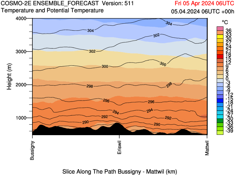
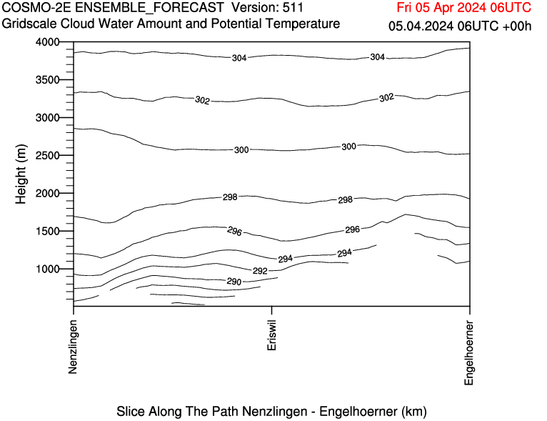
For the CLOUDLAB project we regularly get forecasts that contain a profile at the bottom of the figure from MeteoSwiss that illustrates the terrain nicely (albeit, sometimes it is missing for unknown reasons):
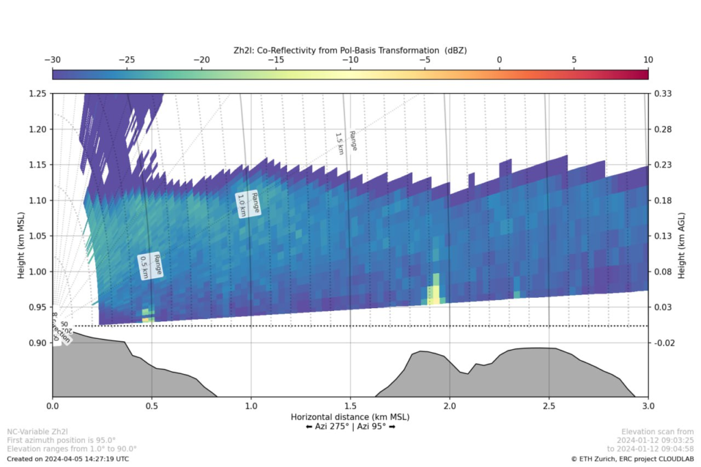
Similarly, I produced a lot of figures of our scans and depending on azimuth and elevation they may be affected by ground clutter, e.g. at a distance of 2 km the increased reflectivity is caused by the terrain below (the hill at around 800 m above sea level). As you can see, I added the terrain already.
Initially, I thought I’d have to get the actual DEM for the area, find the path matching the scan direction and calculate the profile myself. While this might actually be a bit more accurate with a good DEM, it would be more work, not be transferable and mean I’d have to have extra data around. Instead, I realized that swisstopo offers the measure tool on map.geo.admin.ch and uses their own API with a matching request. So I choose to use this as I’m already adding the coordinates for the scan and it is relatively straightforward (min/max of lowest elevation scanline) to get the path we need. The main issue I faced was a misformatted quote that came from copy-pasting the swisstopo example. After finally figuring this out after a detailed URL decode and string comparison the function is relatively lean and can use either the JSON or the CSV backend of the API and by default gives you out a numpy array which can be visualized with ease and can look as follows:
I hope this helps someone to get a profile to enrich their Python (or other) graphs when measuring in Switzerland. In the likely case that you aren’t doing something in Switzerland it might be worthwhile to check out the Google Maps Elevation API (for which you need an API key and billing enabled)
TL;DR; Get population data of the neighbourhoods of Basel
The following SPARQL query allows you to receive the population data from the linked data platform of the city of Basel at a really fine resolution in terms of age.
Basel Stadt publishes many of their dataset (“open by default”), for example, those presented on the “Basler Atlas“. As we’ve seen in another post we can use webscrapping to download them for further analysis. However, one downside if that the data are already aggregated to some extent or grouped (e.g. 0-24, 25-64, 65 – for age, or into gender). This limits a potential analysis to these criteria and means we cannot do a demographic display.
However, I realized that Basel-Stadt is offering also a linked data site (based on the same techstack as LINDAS that I showcased with regards to current hydrodata). Within, you can get some observation sets:
When getting swisstopo altitude profiles the response time is in general quite good but just sometimes I ran into timeouts, be it due to my bad connection or too many requests to the server. To amend I added this decorator that you can get as the most up-to-date version from my GitHub gists to the original swisstopo function (or other functions that might run into some form of timeout)
defexponential_retry(max_retries, delay):"""Retry a request with exponentially increasing (slightly random) time in between tries""""""Usage before def of another function via @exponential_retry(5, 1) """defdecorator_exponential_retry(func):import functools@functools.wraps(func)defwrapper_exponential_retry_decorator(*args, **kwargs):import random retries =0while retries <= max_retries:try:return func(*args, **kwargs)exceptExceptionas e:print(f"Attempt {retries +1} failed: {e}") retries +=1 sleeptime = (delay *2** retries + random.uniform(0, 1))print(f"Retrying in {sleeptime:.2f} seconds...") time.sleep(sleeptime)raiseException("Maximum amount of retries reached, too many timeouts/errors.")return wrapper_exponential_retry_decoratorreturn decorator_exponential_retry@exponential_retry(5, 1)defget_swisstopo_elevation_profile(...): .# source code of get_swisstopo_elevation_profile...
Get the up-to-date data from LINDAS of the currently available values discharge / water level/water temperatures for all BAFU stations.
PREFIX schema:<http://schema.org/>PREFIX hg:<http://rdf.histograph.io/>PREFIX la:<https://linked.art/ns/terms/>prefix ex:<http://example.org/># hydro related prefixesprefix h:<https://environment.ld.admin.ch/foen/hydro/>prefix hd:<https://environment.ld.admin.ch/foen/hydro/dimension/>prefix hgs:<https://environment.ld.admin.ch/foen/hydro/station/>prefix river:<https://environment.ld.admin.ch/foen/hydro/river/observation/>prefix lake:<https://environment.ld.admin.ch/foen/hydro/lake/observation/># geo related prefixesprefix wkt:<http://www.opengis.net/ont/geosparql#asWKT># hydrodata related prefixes (fake) that we use to reference to the historical data. prefix hydrodata:<https://www.hydrodaten.admin.ch/plots/># what we want to get out of the query as "nicely" formatted dataSELECT?station_id?station_name?station_type?station_type_nice?latitude?longitude?station_iri?station_data_iri?station_geometry_iri (group_concat(?measurement_type_measurement_value;SEPARATOR=";") as?data)#?hydrodata_url_temperature ?hydrodata_url_discharge_waterlevel?query_time# add the https://hydrodaten.admin.ch url for the data that go back # 7 days (actually 40 days sometimes, see dev console) (if(contains(?data,"discharge"), uri(concat(str(hydrodata:), 'p_q_7days/',?station_id, '_p_q_7days_de.json')), "") as?hydrodata_url_discharge_waterlevel) (if(contains(?data,"temp"), uri(concat(str(hydrodata:), 'temperature_7days/', ?station_id, '_temperature_7days_de.json')), "") as?hydrodata_url_temperature)where {# it seems counterintuitive but getting everything and filtering # is faster than first getting # the stationlist and go trough their IRI?station?prop?value.# we only want to keep actual data variables and timefilter( ?propin (ex:isLiter, hd:measurementTime, hd:waterTemperature, hd:waterLevel, hd:discharge))# convert the subject station to the id, which is the last thing after the /;bind(replace(replace(str(?station), str(river:), "", "i"),str(lake:), "", "i")as?station_id)# the above is equivalent to this in theory but the above # uses prefixes so would be easier to change# in case of changes#bind(strafter(str(?station), "observation/") as ?station_id2)# get the kind of station this is (whether lake or river) # - the hierarchy/ontology here is weird as all are measurement stations# or observation but the distinction is river/lake first then observationbind(strbefore(strafter(str(?station), str(h:)), "/") as?station_type)# uppercase the first letter -> why is there no capitalize function in SPARQLbind(concat(ucase(substr(?station_type,1,1)), substr(?station_type,2,strlen(?station_type)-1)) as?station_type_nice)# remove some filler words from the databind(replace(str(?prop), str(hd:), "", "i") as?measurement_type)# convert the actual measurement value to a literalbind(str(?value) as?measurement_value)# introduce the time of the query to (maybe) see if the values are oldbind( str(now()) as?query_time)# combine the type of measurement with the value so we # can group by and not loose informationbind(concat(?measurement_type, ';', ?measurement_value, '') as?measurement_type_measurement_value) # start making IRIs so we can check/link back to lindas# the IRI containing information of the station itself (not linked to river/lake)bind(IRI(concat(str(hgs:), ?station_id)) as?station_iri)# generate the geometry IRIbind(IRI(concat(str(hgs:), concat(?station_id,"/geometry"))) as?station_geometry_iri)# generate the station IRI that holds the data informationbind(IRI(concat(str(h:), ?station_type, "/observation/", ?station_id)) as?station_data_iri)# get the information about the location of the station?station_geometry_iriwkt:?coordinates.# also get the name and remove commas to not confuse them with seps?station_irischema:name?stat_name.bind(replace(?stat_name, ',', ';') as?station_name)# simplifiy the geometry to lon/lat in array formBIND(STRBEFORE(STRAFTER(STR(?coordinates), ""), ")") AS?latitude)BIND(STRBEFORE(STRAFTER(STR(?coordinates), "("), "") AS?longitude)}# group by, basically keep everything of the select here# except the ?measurement_type_measurement_value which we want to combine to one row# (ideally we would actually get them as seperate columns again but this seems the best we can do for the momentgroupby# the station information?station_id?station_type?station_type_nice?station_name?latitude?longitude# the IRIs?station_iri?station_data_iri?station_geometry_iri# validation information?query_time
This one took quite some time and serves as of now not much purpose other than training SPARQL for me. Essentially, I was asked once to use “the API” for the current water temperatures that are embedded in my RaspberryPI webcams.
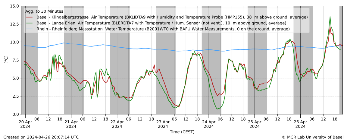
Now, initially I actually “webscapped” the JSON data from hydrodata and transferred them to the MCR database as this allowed the concurrent use of in-house data with the BAFU data. Additionally, the urban/rural/water temperature graph of dolueg2 uses exactly the same temperature, meaning it makes sense to keep it in the same database (at least for some of the relevant stations around Basel, the B2091 means BAFU station 2091).
Now going back to “the API” and RDF where data are in triplet form (subject property object) to allow reuse and linking we can get the most recent data of any of the BAFU stations, via e.g.
prefix hd:<https://environment.ld.admin.ch/foen/hydro/dimension/>SELECT*WHERE {<https://environment.ld.admin.ch/foen/hydro/river/observation/2091>hd:waterTemperature?obj .}# see also the page: https://environment.ld.admin.ch/foen/hydro/river/observation/2091
or some relevant values for us (more than water temperature)
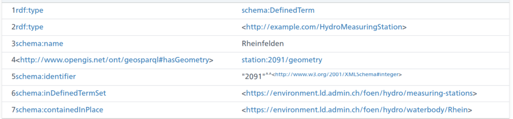
The above is an excerpt of the output from the LINDAS SPARQL endpoint at the time of writing. Notably, we can also get the information for the station (note the added prefix):
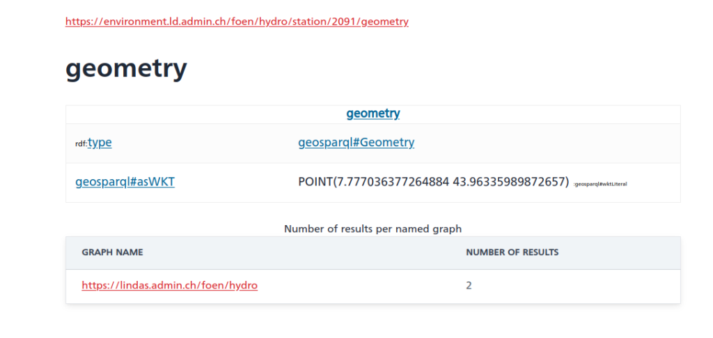
And as you can see, there is also a geometry linked to the station data (shown without query this time):
Cool – except for the fact that the southernmost point of Switzerland is located at 45°49’N. And the station in question (id 2091) is in Rheinfelden, i.e. in the North of Switzerland. So something seems off here and I informed the responsible person in the hopes that they’ll fix that soon.
Now, initially, I thought I’d first extract the IDs of the relevant station, then get their properties of interest/values but somehow the query runs rather slow (6+ seconds); probably this could be fixed and if someone wants to try, the following should give a nicely formatted data table (I actually assume that eventually the trigger for measurement time might not be a good choice when more and more datasets would be available on LINDAS):
PREFIX rdf:<http://www.w3.org/1999/02/22-rdf-syntax-ns#>PREFIX rdfs:<http://www.w3.org/2000/01/rdf-schema#>PREFIX xsd:<http://www.w3.org/2001/XMLSchema#># hydro related prefixesprefix h:<https://environment.ld.admin.ch/foen/hydro/>prefix hd:<https://environment.ld.admin.ch/foen/hydro/dimension/>prefix hydro_geo:<https://environment.ld.admin.ch/foen/hydro/station/># geo related prefixesprefix wkt:<http://www.opengis.net/ont/geosparql#asWKT>select?station_iri?station_id?station_type?coordinates?station_coordinates?query_time?measurement_time?waterTemperature?discharge?waterLevelwhere {?stationhd:measurementTime?measurement_time.optional {?stationhd:waterLevel?waterLevel. }optional { ?stationhd:discharge?discharge.}optional { ?stationhd:waterTemperature?waterTemperature.}# measurement related thingsbind(now() as?query_time)bind(strbefore(strafter(str(?station), str(h:)), "/") as?station_type)bind(strafter(str(?station), "observation/") as?station_id)# geo related things# first find all the relevant subjects, i.e. station property pagesbind(IRI(concat(str(hydro_geo:), concat(?station_id,"/geometry"))) as?station_geometry_iri)bind(IRI(concat(str(hydro_geo:), ?station_id)) as?station_iri)?station_geometry_iriwkt:?coordinates.BIND(strafter(strbefore(str(?coordinates),")"), "POINT(") AS?station_coordinates)# can be used for yasgui and nicer representation but slows the query#bind(xsd:decimal(?station_id) as ?station_id_numeric)} #order by desc(?station_id_numeric)
As you can see, it’s important to use the OPTIONAL keyword as not all stations have all variables (water temperature / discharge / level). Additionally, I retrieve the kind of station (lake/river) that is available. The choice of prefix for these is a bit weird for my feeling as the hierarchy seems to be river/lake then station instead of the other way around – which must have a reason that I’m too inexperienced to understand. The rest of the query is cosmetics to get a bit nicer values (keep the geometry as proper type and you can get a map of the observations though).
As seen, this runs rather slow (6+ seconds for around 230 records is too slow on any day) so I started experimenting, arriving ultimately at the code at the top (here shortened to remove geometry and hydrodata links) by first filtering out the relevant dimensions, essentially getting the data first, then cleaning up a bit and concatenating by station id.
PREFIX schema:<http://schema.org/>PREFIX hg:<http://rdf.histograph.io/>PREFIX la:<https://linked.art/ns/terms/>prefix ex:<http://example.org/># hydro related prefixesprefix h:<https://environment.ld.admin.ch/foen/hydro/>prefix hd:<https://environment.ld.admin.ch/foen/hydro/dimension/>prefix hgs:<https://environment.ld.admin.ch/foen/hydro/station/>prefix river:<https://environment.ld.admin.ch/foen/hydro/river/observation/>prefix lake:<https://environment.ld.admin.ch/foen/hydro/lake/observation/># geo related prefixesprefix wkt:<http://www.opengis.net/ont/geosparql#asWKT># what we want to get out of the query as "nicely" formatted dataSELECT?station_id?station_name?station_type?station_type_nice?station_iri?station_data_iri (group_concat(?measurement_type_measurement_value;SEPARATOR=", ") as?data)#?hydrodata_url_temperature ?hydrodata_url_discharge_waterlevel?query_timewhere {# it seems counterintuitive but getting everything and filtering is faster than first getting # the stationlist and go trough their IRI?station?prop?value.# we only want to keep actual data variables and timefilter( ?propin (hd:measurementTime, hd:waterTemperature, hd:waterLevel, hd:discharge))# convert the subject station to the id, which is the last thing after the /;bind(replace(replace(str(?station), str(river:), "", "i"),str(lake:), "", "i")as?station_id)# the above is equivalent to this in theory but the above uses prefixes so would be easier to change# in case of changes#bind(strafter(str(?station), "observation/") as ?station_id2)# get the kind of station this is (whether lake or river) - the hierarchy/ontology here is weird as all are measurement stations# or observation but the distinction is river/lake first then observationbind(strbefore(strafter(str(?station), str(h:)), "/") as?station_type)# uppercase the first letter -> why is there no capitalize function in SPARQL (╯°□°)╯︵ ┻━┻bind(concat(ucase(substr(?station_type,1,1)), substr(?station_type,2,strlen(?station_type)-1)) as?station_type_nice)# remove some filler words from the databind(replace(replace(replace(str(?prop), str(hd:), "", "i"),"water", "", "i"),"measurementTime", "measurement_time", "i") as?measurement_type)# convert the actual measurement value to a literalbind(str(?value) as?measurement_value)# introduce the time of the query to (maybe) see if the values are oldbind( str(now()) as?query_time)# combine the type of measurement with the value so we can group by and not loose informationbind(concat(?measurement_type, ': ', ?measurement_value, '') as?measurement_type_measurement_value) # start making IRIs so we can check/link back to lindas# the IRI containing information of the station itself (not linked to river/lake)bind(IRI(concat(str(hgs:), ?station_id)) as?station_iri)}# group by, basically keep everything of the select here# except the ?measurement_type_measurement_value which we want to combine to one row# (ideally we would actually get them as seperate columns again but this seems the best we can do for the momentgroupby# the station information?station_id?station_type?station_type_nice?station_name# the IRIs?station_iri?station_data_iri# validation information?query_time
This query is the reduced version of the one on top. It runs in around 1 second or less and can now be used for automated queries or other products as described here on LINDAS. The only additions are the added geometry and the URLs for the hydrodata website that give you the historical data to implement a product I have in mind that might come up later. And maybe at some point, we can also get data from the past on LINDAS, making the project I have in mind easier.
Update: The offset in the geometry seems to be consistently 400’000 m in “hochwert”/latitude based on three stations picked from hydrodata and LINDAS where longitude is almost correct:
b =2634026 , 1125901# 2531a =7.854351126515431, 42.67878915566025# 2531a = wgs84_to_ch1903(*a[::-1], plus=True)[::-1]print([i - j for i, j inzip(a, b)])#out: [132.7675012690015, -401020.22037598956]b =2627189 , 1267845# 2091a =7.777036377264884, 43.96335989872657# 2091a = wgs84_to_ch1903(*a[::-1], plus=True)[::-1]print([i - j for i, j inzip(a, b)])#out: [1.471713425591588, -399994.8737920185]b =2830800 , 1168706# 2617a =10.265672193049967, 43.036021653211186# 2617a = wgs84_to_ch1903(*a[::-1], plus=True)[::-1]print([i - j for i, j inzip(a, b)])#out: [48.71478863572702, -399969.5114403835]